1970s Maps of Lawrence County, Missouri
Explore 11 historic maps of Lawrence County from the 1970s. These maps offer a rare glimpse into what life looked like during the 1970s — showing old roads, neighborhoods, homes, and landmarks that have changed or disappeared over time.
Whether you're researching your family's past, planning a metal detecting trip, or studying how Lawrence County's landscape evolved across the 1970s, these high-resolution maps are a powerful tool for exploring the history of this region.
- Focus on a specific era: All maps on this page are from the 1970s, giving you a focused view of this time period.
- See what’s changed: Compare century-old streets, trails, and buildings to today's modern landscape using overlays and satellite layers.
- Research with precision: Use these maps for genealogy, historical research, land use analysis, or educational projects.
- View, download, or print: Maps are fully viewable online in high resolution, and can be downloaded or printed for your own records.
Start exploring Lawrence County's history through authentic maps from the 1970s. This is your window into the past.
Lawrence County, MO maps
(11)- 1971 Map of Miller, 1973 Print
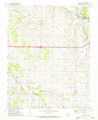
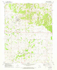 1971 Miller1973 Print · USGSLawrence County farming life in the early 1970s is centered around the town of Miller and several outlying rural communities. Researchers can trace land ownership and family history through numerous landmarks like Hickman Cem, Summit Ch, and the Old Railroad Grade.
 - 1971 Map of Mount Vernon, 1973 Print
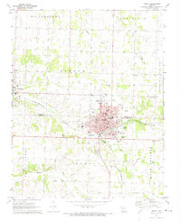
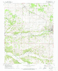
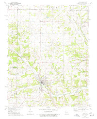
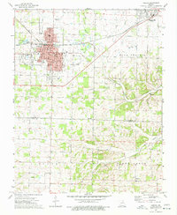
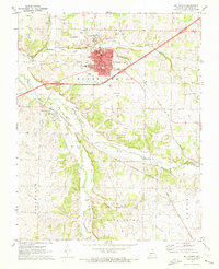 1971 Mount Vernon1973 Print · USGSMount Vernon and the surrounding Ozark foothills are captured here in the early seventies during a period of steady local growth. Researchers can trace the family names of early settlers through numerous burial grounds like Spanish Fort Cem and Williams Cem, or locate the sprawling State Sanatorium complex.
 - 1971 Map of Sarcoxie, 1973 Print
 1971 Sarcoxie1973 Print · USGSSarcoxie and the surrounding townships in the early seventies sit at the intersection of three Missouri counties. Researchers can trace the St Louis - San Francisco rail line and locate rural landmarks like Cave Spring Cem, Clarkson Spring, and Bethany Ch.
 - 1971 Map of Rescue, 1973 Print
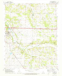
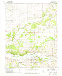
 1971 Rescue1973 Print · USGSLawrence County in the early seventies shows a landscape defined by the Spring River and the Missouri Pacific railroad. Genealogists and local historians can trace family locations near Stotts City (Sta), Stone Chapel, and the Goss Cem.
 - 1971 Map of Stotts City, 1973 Print
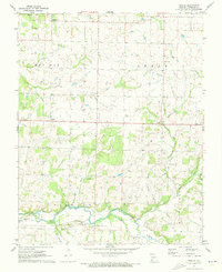
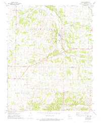
 1971 Stotts City1973 Print · USGSLawrence County's agricultural and academic landscape is captured here in the early 1970s. Trace the rural community's roots through sites like Baptist Hill Assembly, Stotts City Cem, and the University of Missouri Experimental Farm.
 - 1971 Map of La Russell, 1973 Print
 1971 La Russell1973 Print · USGSThe Jasper and Lawrence County border area is seen here in the early 1970s, focused on the Spring River valley. Researchers can trace local lineage through numerous sites like Bowers Mill, Stemons Cem, and White Oak Ch.
 - 1972 Map of Monett, 1973 Print
 1972 Monett1973 Print · USGSMonett and Pierce City sit at a critical rail junction in the early seventies, marking a landscape defined by small-town industry and traditional community centers. Genealogists can locate family landmarks like Waldensian Church, St Marys Cemetery, and Liberty Church Cemetery.
 - 1972 Map of Verona, 1973 Print
 1972 Verona1973 Print · USGSThe Lawrence and Barry County border comes to life in the early seventies as the St Louis - San Francisco rail line cuts through Verona. Genealogists can trace family footprints at New Liberty Ch and Spring River Cem.
 - 1972 Map of Pierce City, 1973 Print
 1972 Pierce City1973 Print · USGSThe rail-and-creek landscape of Southwest Missouri comes to life in the early seventies, showing the area as the railroad era matured. Genealogists and historians can trace families near Pierce City, Yonkerville, and the rural Berwick Ch.
 - 1974 Map of Crane, 1977 Print
 1974 Crane1977 Print · USGSStone County and the settlement of Crane are documented here in the mid-seventies, showing a landscape defined by railroad corridors and spring-fed hollows. Family historians can locate several local burial grounds and churches, including the Masonic Cem, Hood Cem, and Shiloh Ch.
 - 1974 Map of Aurora, 1977 Print
 1974 Aurora1977 Print · USGSAurora and the surrounding Ozark foothills are captured here in the mid-1970s, showcasing the region's transition from prairie to plateau. Researchers can trace historic family landmarks such as Buck Prairie Cem, Wise Spring, and the rural community of Revisville.
End of results
Showing maps 1-11 of 11
Top cities of Lawrence County
- Aurora historical maps
- Mount Vernon historical maps
- Marionville historical maps
- Pierce City historical maps
- Verona historical maps
- Miller historical maps
See more
Frequently asked questions
- What are the different types of historical maps available for Lawrence County?
- What is the oldest map of Lawrence County?
- Where can I purchase historical maps of Lawrence County for my home or office?
- Where can I download high-res historical maps of Lawrence County?
- Are there historical topographic maps available for Lawrence County?
- Is there historical aerial imagery available for Lawrence County?
- Where are historical maps of Lawrence County sourced from?