Old Maps of Lawrence County, Missouri for Genealogy
Trace your family roots with 133 historic maps of Lawrence County. These high-res maps reveal old neighborhoods, homesites, landmarks, and streets — helping you uncover where your ancestors lived and how the area evolved over time.
- Explore historic neighborhoods: Identify where your relatives may have lived in the 1800s or 1900s.
- Compare maps over time: Trace the changes in streets, buildings, and landmarks for multi-generational research.
- Perfect for genealogy & ancestry research: Used by family historians and researchers to map out lineage and migration.
These maps are an incredible resource for exploring your personal connection to Lawrence County's past.
Lawrence County, MO maps
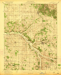
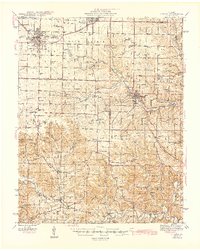
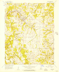
(133)- 1886 Map of Greenfield
 1886 Greenfield1886 Print · USGSSouthwest Missouri was undergoing a rail-driven transformation in the 1880s, as new lines connected established county seats to outlying farm towns. Genealogists can trace family roots through numerous small settlements like Paris Springs, Dadeville, and the thriving rail hub at Ash Grove.4 unique versions available
 - 1886 Map of Carthage
 1886 Carthage1886 Print · USGSJasper and Barton Counties thrive during the mid-1880s as the railroad era transforms the Missouri landscape into a bustling corridor of trade and industry. Genealogists and historians can trace the early footprints of Carthage, the mills at Bowers Mill, and the early rail connections through Webb City and Oronogo.
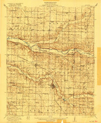
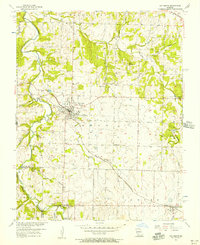
 - 1888 Map of Greenfield, 1898 Print
 1888 Greenfield1898 Print · USGSSouthwest Missouri thrived as a budding rail and agricultural hub in the 1880s. Local researchers can trace the early footprints of Greenfield and Mount Vernon, alongside smaller settlements like Paris Springs and Everton.
 - 1894 Map of Carthage
 1894 Carthage1894 Print · USGSSouthwest Missouri thrived as a rail and mining hub in the late nineteenth century. Genealogists can trace family roots through old settlements like Diamond City, Dudenville, and Bowers Mill during this period of growth.5 unique versions available
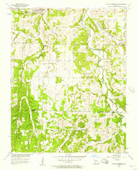
 - 1919 Map of Halltown
 1919 Halltown1919 Print · USGSThe Missouri Ozarks are captured here during a time of dense rural settlement across Lawrence and Greene counties. Genealogists can locate dozens of country schools and churches, from Buck Prairie School to Mt Olive Church and Wade Chapel Cemetery.3 unique versions available
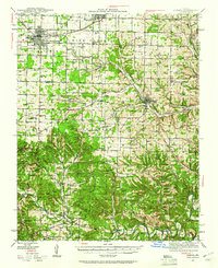
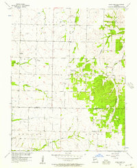
 - 1921 Map of Stotts City
 1921 Stotts City1921 Print · USGSLawrence County, Missouri, is captured here during the peak of its rail-driven settlement in the early nineteen-twenties. Genealogists and historians can locate dozens of country schools and family landmarks, from the Spanish Fort School to the Roberts Cemetery.2 unique versions available
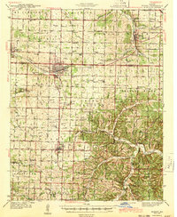
 - 1921 Map of Sarcoxie
 1921 Sarcoxie1921 Print · USGSJasper and Newton counties in the early 1920s reveal a flourishing agricultural landscape centered on the rail lines of the Pacific and Frisco. Genealogists and local historians can locate dozens of rural landmarks, from the Red Fox Mine to Union Chapel and Forest Mills.2 unique versions available
 - 1942 Map of Aurora, 1961 Print
 1942 Aurora1961 Print · USGSThe northern Ozarks come to life in this mid-century survey of the rugged borderlands where three counties meet. Researchers can trace the path of the Missouri Pacific railroad through Aurora or locate family roots at rural landmarks like Charity Cem and Mountain Home Sch.2 unique versions available
 - 1943 Map of Ritchey
 1943 Ritchey1943 Print · USGSSouthwest Missouri during the war years shows a landscape of busy railroads and emerging military sites. Genealogists can trace family roots through numerous local landmarks like Odd Fellows Cem, Dungy Mine, and rural centers such as Stark City.2 unique versions available
 - 1943 Map of Monett
 1943 Monett1943 Print · USGSCrossing the Barry and Lawrence County line during the mid-forties, this map reveals the vital railroad hub at Monett and its surrounding farmsteads. Genealogists can trace family names through landmarks like Red Mill, Arnold Chapel, and the Cox Cem.3 unique versions available
 - 1945 Map of Harrison
 1945 Harrison1945 Print · USGSThe Ozark and Boston Mountains straddle the Missouri-Arkansas border during the mid-forties, showing a landscape of forest ridges and river valleys. Genealogists and historians can trace rail-connected towns like Monett and West Plains or early lake developments at Bull Shoals Res and Norfork Lake.
 - 1945 Map of Aurora
 1945 Aurora1945 Print · USGSThe Ozark plateau around Aurora and Crane is captured here during the mid-forties, showing a landscape defined by rail junctions and rural school districts. Researchers can trace ancestral locations like Stubblefield Cem, the Clay Hill Ch, and old springs including Bean Factory Spr.2 unique versions available
 - 1947 Map of Joplin, 1954 Print
 1947 Joplin1954 Print · USGSThe borderlands of Missouri, Kansas, and Oklahoma are shown here during the late 1940s, a period of heavy industrial and military activity. Researchers can trace the extensive Tri-State Mining District, the layout of Camp Crowder, and local landmarks like Mount Hope Cem.
 - 1949 Map of Joplin
 1949 Joplin1949 Print · USGSThe Kansas-Missouri borderlands thrive in the late 1940s, showing a robust network of railroad towns and river valleys. Researchers can trace historic rail lines like the Missouri Pacific RR and locate rural centers such as Chanute, Iola, and Fort Scott.
 - 1949 Map of Harrison
 1949 Harrison1949 Print · USGSThe Ozark highlands of northern Arkansas and southern Missouri are shown just after the war, when the White River still followed its original course. Genealogists and historians can trace rail lines like the Missouri & Arkansas RR and locate rural hubs like Harrison, Eureka Springs, and Mountain Home.
 - 1954 Map of Harrison
 1954 Harrison1954 Print · USGSThe Ozarks and Boston Mountains meet during a period of massive river engineering in the mid-fifties. Researchers can trace the early shorelines of Bull Shoals Lake and Table Rock Reservoir or locate inland towns like Berryville and Harrison.
 - 1954 Map of Tulsa
 1954 Tulsa1954 Print · USGSNortheast Oklahoma and the Ozark border are shown here during a period of massive industrial and infrastructure growth. Researchers can trace the legacy of the Tri-State Mining District and the development of major reservoirs like Grand Lake O' The Cherokees.2 unique versions available
 - 1954 Map of Springfield
 1954 Springfield1954 Print · USGSThe Missouri Ozarks are captured here during the post-war era, showing the expansion of Springfield and the surrounding river valleys. Genealogists and historians can trace local landmarks like Mount Comfort Cemetery and the Fort Leonard Wood military grounds.6 unique versions available
 - 1954 Map of Joplin, 1967 Print
 1954 Joplin1967 Print · USGSThe tri-state border region of Kansas, Missouri, and Oklahoma is captured here during a peak era of mid-century industrial and agricultural activity. Researchers can trace family history through dozens of rural cemeteries or locate landmarks like the Kansas Army Ammunition Plant and Pittsburg State University.3 unique versions available
 - 1956 Map of Ash Grove, 1957 Print
 1956 Ash Grove1957 Print · USGSWestern Greene County in the mid-1950s is defined by the crossing of the St Louis San Francisco railroad and the winding Sac River. Genealogists can trace family footprints through sites like Hamilton Cem, Johns Chapel, and the established streets of Ash Grove.2 unique versions available
 - 1956 Map of Kings Point, 1957 Print
 1956 Kings Point1957 Print · USGSThe rural borderlands of Dade and Lawrence counties come into focus during the mid-1950s. Genealogists and local historians can trace the early road networks connecting Meinert, Kings Point, and Round Grove, or locate the rural Salem Ch.
 - 1956 Map of South Greenfield, 1957 Print
 1956 South Greenfield1957 Print · USGSThe rural borderlands of Dade and Lawrence counties are shown here in the mid-fifties, centered on the railroad town of South Greenfield. Researchers can trace old family burial grounds like Daughtrey Cem and Merrick Cem or locate local landmarks like Dilday Mill and Carrico Caves.
 - 1956 Map of Everton, 1957 Print
 1956 Everton1957 Print · USGSEverton and the surrounding Rock Prairie uplands are captured here in the mid-fifties, showing the vital link between the St Louis San Francisco railroad and local agriculture. Researchers can trace rural life through sites like Hopewell Sch, Liberty Ch, and the Hood Cem.2 unique versions available
 - 1958 Map of Springfield
 1958 Springfield1958 Print · USGSThe Missouri Ozarks are captured during the mid-century era of growth, centered on the bustling hub of Springfield. Genealogists and historians can trace family roots through numerous landmarks like Ebenezer Church, Stockton Cem, and the various county courthouses.
 - 1958 Map of Joplin
 1958 Joplin1958 Print · USGSThe tri-state border region of Missouri, Kansas, and Oklahoma is shown during the late fifties, a time of heavy rail traffic and mining activity. Local historians can trace the industrial landscape through the Joplin & Pittsburg Ry or locate family sites like Zion Ch and Bender Mounds.
Showing maps 1-25 of 133
Top cities of Lawrence County
- Aurora historical maps
- Mount Vernon historical maps
- Marionville historical maps
- Pierce City historical maps
- Verona historical maps
- Miller historical maps
See more
Frequently asked questions
- What are the different types of historical maps available for Lawrence County?
- What is the oldest map of Lawrence County?
- Where can I purchase historical maps of Lawrence County for my home or office?
- Where can I download high-res historical maps of Lawrence County?
- Are there historical topographic maps available for Lawrence County?
- Is there historical aerial imagery available for Lawrence County?
- Where are historical maps of Lawrence County sourced from?