1960s Maps of Lawrence County, Missouri
Explore 7 historic maps of Lawrence County from the 1960s. These maps offer a rare glimpse into what life looked like during the 1960s — showing old roads, neighborhoods, homes, and landmarks that have changed or disappeared over time.
Whether you're researching your family's past, planning a metal detecting trip, or studying how Lawrence County's landscape evolved across the 1960s, these high-resolution maps are a powerful tool for exploring the history of this region.
- Focus on a specific era: All maps on this page are from the 1960s, giving you a focused view of this time period.
- See what’s changed: Compare century-old streets, trails, and buildings to today's modern landscape using overlays and satellite layers.
- Research with precision: Use these maps for genealogy, historical research, land use analysis, or educational projects.
- View, download, or print: Maps are fully viewable online in high resolution, and can be downloaded or printed for your own records.
Start exploring Lawrence County's history through authentic maps from the 1960s. This is your window into the past.
Lawrence County, MO maps
(7)- 1962 Map of Dudenville, 1963 Print
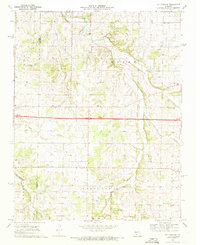
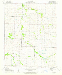 1962 Dudenville1963 Print · USGSSouthwest Missouri farmland and rural townships are captured here in the early 1960s at the junction of four counties. Genealogists and local historians can trace the foundations of Dudenville, the location of Unity Sch, and the grounds of Kistler Cem.2 unique versions available
 - 1963 Map of Tulsa
 1963 Tulsa1963 Print · USGSThe Oklahoma and Arkansas borderlands are shown here in the early sixties, a time of massive reservoir construction and heavy mining. Genealogists can trace family roots through settlements like Nowata, Pryor, and Jay, or locate historical zinc and lead mines and coal mines.
 - 1964 Map of Harrison
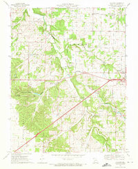
 1964 Harrison1964 Print · USGSThe Ozark and Boston Mountains of Arkansas and Missouri are captured here in the mid-sixties, showing the rugged highlands before extensive modern development. Genealogists and historians can trace family-named peaks like Gaither Mountain and follow the St Louis-San Francisco RR through Monett and Purdy.
 - 1969 Map of Halltown, 1971 Print
 1969 Halltown1971 Print · USGSLawrence County's eastern townships are shown here during the late sixties, where the Ozark Plateau meets a network of spring-fed creeks. Researchers can trace rural lineages through sites like Rock Prairie Cem and Paris Springs Ch or locate the Downing Farm Landing Field.
 - 1969 Map of Chesapeake, 1971 Print
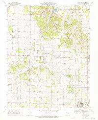 1969 Chesapeake1971 Print · USGSLawrence County farming and rail life are captured here in the late sixties, centered on the community of Marionville. Genealogists can trace family roots through several rural landmarks, from McNatt Chapel and Dover Ch to the Grammer Cem.2 unique versions available
 - 1969 Map of Billings, 1971 Print
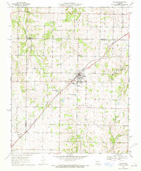 1969 Billings1971 Print · USGSThe Missouri prairie south of Springfield is captured here in the late sixties, centered on the rail junction at Billings. Genealogists and local historians can locate several rural burial grounds and churches, including St Peters Cem, Smart Cem, and Blades Chapel.2 unique versions available
 - 1969 Map of Halltown NE, 1971 Print
 1969 Halltown NE1971 Print · USGSThe Missouri Ozarks are captured here in the late sixties as modern highways began to bypass traditional hubs like Halltown. Researchers can locate several family burial grounds such as Batson Cem and Garoutte Cem alongside landmarks like the Downing Farm Landing Field.2 unique versions available
End of results
Showing maps 1-7 of 7
Top cities of Lawrence County
- Aurora historical maps
- Mount Vernon historical maps
- Marionville historical maps
- Pierce City historical maps
- Verona historical maps
- Miller historical maps
See more
Frequently asked questions
- What are the different types of historical maps available for Lawrence County?
- What is the oldest map of Lawrence County?
- Where can I purchase historical maps of Lawrence County for my home or office?
- Where can I download high-res historical maps of Lawrence County?
- Are there historical topographic maps available for Lawrence County?
- Is there historical aerial imagery available for Lawrence County?
- Where are historical maps of Lawrence County sourced from?