Old Maps of Lawrence County, Missouri
Explore 53 old maps of Lawrence County, spanning from 1886 to today. These high-resolution historic maps reveal how streets, neighborhoods, landmarks, and natural features evolved over time — perfect for genealogy, metal detecting, research, and local history exploration.
What you can do with these maps:
- See how Lawrence County changed over time: Compare historical maps to modern-day views to trace roads, homesites, rail lines & more.
- View detailed metadata: Each map includes creators, publishers, year, scale, and archive source.
- Overlay maps with satellite & LiDAR: Visualize the past alongside modern tools to explore terrain & human change.
- Trusted historical sources: Maps sourced from the USGS, Library of Congress, and other archives.
- Access maps your way: View online, download high-res files, or order prints for personal or research use.
Start exploring old maps of Lawrence County to uncover forgotten places, hidden landmarks, and the deep history beneath your feet.
Lawrence County, MO maps
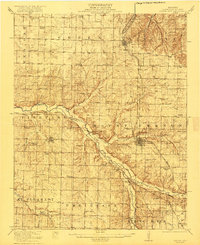
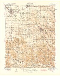
(53)- 1886 Map of Greenfield
 1886 Greenfield1886 Print · USGSCovers Lawrence County, including Republic, Mount Vernon, and other nearby areas4 unique versions available
 - 1886 Map of Carthage
 1886 Carthage1886 Print · USGSCovers Lawrence County, including Joplin, Carthage, and other nearby areas
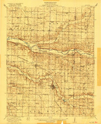
 - 1888 Map of Greenfield, 1898 Print
 1888 Greenfield1898 Print · USGSCovers Lawrence County, including Republic, Mount Vernon, and other nearby areas
 - 1894 Map of Carthage
 1894 Carthage1894 Print · USGSCovers Lawrence County, including Joplin, Carthage, and other nearby areas5 unique versions available
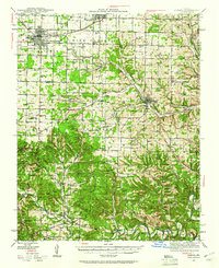
 - 1919 Map of Halltown
 1919 Halltown1919 Print · USGSCovers Lawrence County, including Republic, Marionville, and other nearby areas3 unique versions available
 - 1921 Map of Stotts City
 1921 Stotts City1921 Print · USGSCovers Lawrence County, including Mount Vernon, Miller, and other nearby areas3 unique versions available
 - 1921 Map of Sarcoxie
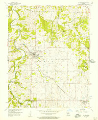
 1921 Sarcoxie1921 Print · USGSCovers Lawrence County, including Sarcoxie, La Russell, and other nearby areas2 unique versions available
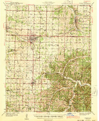
 - 1942 Map of Aurora, 1961 Print
 1942 Aurora1961 Print · USGSCovers Lawrence County, including Aurora, Marionville, and other nearby areas2 unique versions available
 - 1943 Map of Ritchey
 1943 Ritchey1943 Print · USGSCovers Lawrence County, including Monett, Granby, and other nearby areas2 unique versions available
 - 1943 Map of Monett
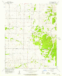
 1943 Monett1943 Print · USGSCovers Lawrence County, including Monett, Pierce City, and other nearby areas3 unique versions available
 - 1945 Map of Harrison
 1945 Harrison1945 Print · USGSCovers Lawrence County, including Ozark, Harrison, and other nearby areas
 - 1945 Map of Aurora
 1945 Aurora1945 Print · USGSCovers Lawrence County, including Aurora, Marionville, and other nearby areas2 unique versions available
 - 1947 Map of Joplin, 1954 Print
 1947 Joplin1954 Print · USGSCovers Lawrence County, including Joplin, Pittsburg, and other nearby areas
 - 1949 Map of Joplin
 1949 Joplin1949 Print · USGSCovers Lawrence County, including Joplin, Pittsburg, and other nearby areas
 - 1949 Map of Harrison
 1949 Harrison1949 Print · USGSCovers Lawrence County, including Ozark, Harrison, and other nearby areas
 - 1954 Map of Harrison
 1954 Harrison1954 Print · USGSCovers Lawrence County, including Ozark, Harrison, and other nearby areas
 - 1954 Map of Tulsa
 1954 Tulsa1954 Print · USGSCovers Lawrence County, including Tulsa, Broken Arrow, and other nearby areas2 unique versions available
 - 1954 Map of Springfield
 1954 Springfield1954 Print · USGSCovers Lawrence County, including Springfield, Nixa, and other nearby areas6 unique versions available
 - 1954 Map of Joplin, 1967 Print
 1954 Joplin1967 Print · USGSCovers Lawrence County, including Joplin, Pittsburg, and other nearby areas3 unique versions available
 - 1956 Map of Ash Grove, 1957 Print
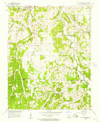
 1956 Ash Grove1957 Print · USGSCovers Lawrence County, including Ash Grove, Bois D'Arc, and other nearby areas2 unique versions available
 - 1956 Map of Kings Point, 1957 Print
 1956 Kings Point1957 Print · USGSCovers Lawrence County, including Meinert, Round Grove, and other nearby areas
 - 1956 Map of South Greenfield, 1957 Print
 1956 South Greenfield1957 Print · USGSCovers Lawrence County, including Pilgrim, South Greenfield, and other nearby areas
 - 1956 Map of Everton, 1957 Print
 1956 Everton1957 Print · USGSCovers Lawrence County, including Everton, Greene County, and other nearby areas2 unique versions available
 - 1958 Map of Springfield
 1958 Springfield1958 Print · USGSCovers Lawrence County, including Springfield, Nixa, and other nearby areas
 - 1958 Map of Joplin
 1958 Joplin1958 Print · USGSCovers Lawrence County, including Joplin, Pittsburg, and other nearby areas
Showing maps 1-25 of 53
Top cities of Lawrence County
- Aurora historical maps
- Mount Vernon historical maps
- Marionville historical maps
- Pierce City historical maps
- Verona historical maps
- Miller historical maps
See more
Frequently asked questions
- What are the different types of historical maps available for Lawrence County?
- What is the oldest map of Lawrence County?
- Where can I purchase historical maps of Lawrence County for my home or office?
- Where can I download high-res historical maps of Lawrence County?
- Are there historical topographic maps available for Lawrence County?
- Is there historical aerial imagery available for Lawrence County?
- Where are historical maps of Lawrence County sourced from?