1960s Maps of Linn County, Missouri
Explore 5 historic maps of Linn County from the 1960s. These maps offer a rare glimpse into what life looked like during the 1960s — showing old roads, neighborhoods, homes, and landmarks that have changed or disappeared over time.
Whether you're researching your family's past, planning a metal detecting trip, or studying how Linn County's landscape evolved across the 1960s, these high-resolution maps are a powerful tool for exploring the history of this region.
- Focus on a specific era: All maps on this page are from the 1960s, giving you a focused view of this time period.
- See what’s changed: Compare century-old streets, trails, and buildings to today's modern landscape using overlays and satellite layers.
- Research with precision: Use these maps for genealogy, historical research, land use analysis, or educational projects.
- View, download, or print: Maps are fully viewable online in high resolution, and can be downloaded or printed for your own records.
Start exploring Linn County's history through authentic maps from the 1960s. This is your window into the past.
Linn County, MO maps
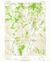
(5)- 1960 Map of Moberly
 1960 Moberly1960 Print · USGSCentral Missouri comes alive in the mid-twentieth century as a bustling network of river towns and significant rail corridors. Genealogists and historians can trace the paths of the Wabash RR through Moberly or explore the riverfronts of Lexington and Brunswick.
 - 1963 Map of Nind, 1965 Print
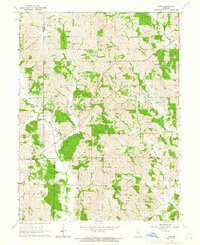 1963 Nind1965 Print · USGSNorth central Missouri agriculture and small-town life are documented here during the early sixties. Genealogists can locate family landmarks like Hall Cem, Mt Carmel Ch, and the rural Willow Branch Sch near the county lines.
 - 1963 Map of Winigan, 1965 Print
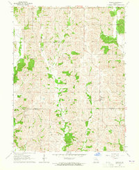 1963 Winigan1965 Print · USGSThe borderlands of Sullivan and Linn Counties come into focus in the early sixties, showing a landscape of small farms and creek-side settlements. Genealogists can trace family roots through several rural burial sites like Bunch Cem, Tallman Cem, and Price Cem.2 unique versions available
 - 1964 Map of Milan SE, 1965 Print
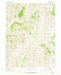 1964 Milan SE1965 Print · USGSThe rural borderlands of Sullivan and Linn County come to life in the mid-1960s, showing a landscape of family farms and creek-side settlements. Genealogists can trace local history through markers like Mt Zion Ch, Brittain Cem, and the village of Enterprise.
 - 1964 Map of Browning, 1965 Print
 1964 Browning1965 Print · USGSBrowning straddles the county line in northern Missouri during the mid-sixties, an area shaped by the winding Locust Creek and a network of small family farms. Genealogists and historians can trace numerous rural landmarks like Locust Valley Ch and family burial sites including White Oak Cem and Jenkins Cem.
End of results
Showing maps 1-5 of 5
Top cities of Linn County
- Brookfield historical maps
- Marceline historical maps
- Bucklin historical maps
- Meadville historical maps
- Laclede historical maps
- Linneus historical maps
See more
Frequently asked questions
- What are the different types of historical maps available for Linn County?
- What is the oldest map of Linn County?
- Where can I purchase historical maps of Linn County for my home or office?
- Where can I download high-res historical maps of Linn County?
- Are there historical topographic maps available for Linn County?
- Is there historical aerial imagery available for Linn County?
- Where are historical maps of Linn County sourced from?