1980s Maps of Linn County, Missouri
Explore 12 historic maps of Linn County from the 1980s. These maps offer a rare glimpse into what life looked like during the 1980s — showing old roads, neighborhoods, homes, and landmarks that have changed or disappeared over time.
Whether you're researching your family's past, planning a metal detecting trip, or studying how Linn County's landscape evolved across the 1980s, these high-resolution maps are a powerful tool for exploring the history of this region.
- Focus on a specific era: All maps on this page are from the 1980s, giving you a focused view of this time period.
- See what’s changed: Compare century-old streets, trails, and buildings to today's modern landscape using overlays and satellite layers.
- Research with precision: Use these maps for genealogy, historical research, land use analysis, or educational projects.
- View, download, or print: Maps are fully viewable online in high resolution, and can be downloaded or printed for your own records.
Start exploring Linn County's history through authentic maps from the 1980s. This is your window into the past.
Linn County, MO maps
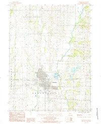
(12)- 1981 Map of Chillicothe
 1981 Chillicothe1981 Print · USGSNorth Missouri's Grand River basin comes into focus during the early 1980s, showcasing a network of vital rail lines and river settlements. Genealogists and historians can trace rail-town development from Gallatin to Brookfield and explore extensive conservation lands like Swan Lake National Wildlife Refuge.
 - 1981 Map of Macon
 1981 Macon1981 Print · USGSNorthern Missouri's rail-and-river landscape is captured here in the early eighties, centered on the crossroads of Macon. Researchers can trace old cemetery sites like St Marys Cem, local landmarks such as College Mound, and the routes of the Burlington Northern railroad.
 - 1981 Map of Trenton
 1981 Trenton1981 Print · USGSNorthern Missouri in the early eighties remains a landscape defined by its river valleys and intersecting rail lines. Genealogists and local historians can trace the development of riverside towns like Trenton and Princeton or locate smaller rural junctions such as Humphreys and Brimson.
 - 1981 Map of Kirksville, 1982 Print
 1981 Kirksville1982 Print · USGSNortheast Missouri in the early eighties was a landscape of rail-connected trade towns and significant river valleys. Researchers can trace the legacy of medical education at the Kirksville College of Osteopathic Med or locate family roots in Unionville, Edina, and Bible Grove.
 - 1984 Map of Laclede, 1985 Print
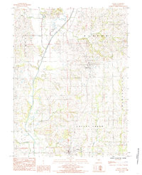
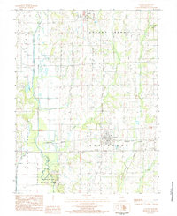 1984 Laclede1985 Print · USGSLinn County in the early eighties centers on the railroad town of Laclede and the southern reaches of Linneus. Researchers can trace the wetlands of Pershing State Park and rural landmarks like the Burlington Northern rail line and local Cem sites.
 - 1984 Map of Meadville, 1985 Print
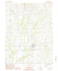 1984 Meadville1985 Print · USGSMeadville sits at the center of this Linn County landscape during the mid-1980s, anchored by its proximity to the railroad. Genealogists and local historians can trace the rural property patterns near Parson Creek and the steel rails of the Burlington Northern.
 - 1984 Map of Fountain Grove, 1985 Print
 1984 Fountain Grove1985 Print · USGSThe river bottoms of Livingston and Linn counties are captured here in the mid-1980s, showcasing a landscape shaped by water and rail. Genealogists and local historians can trace the paths of the Norfolk and Western railroad and locate rural settlements like Bedford and Towstring.
 - 1984 Map of Shelby, 1985 Print
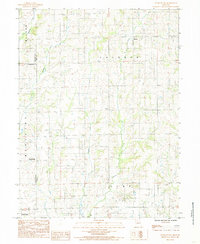
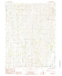 1984 Shelby1985 Print · USGSThe rural community of Shelby and the surrounding townships of Linn County are captured here in the early 1980s. Trace the winding paths of West Yellow Creek, Big Turkey Creek, and Bear Creek as they carve through this traditional Missouri farm landscape.
 - 1984 Map of Lindley, 1985 Print
 1984 Lindley1985 Print · USGSSullivan County and the surrounding tri-county borderlands are captured here in the early eighties as a network of rural townships and winding creeks. Genealogists and local researchers can trace family lands near Humphreys, Lindley, and the small settlement of Haseville.
 - 1984 Map of Brookfield, 1985 Print
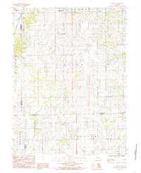
 1984 Brookfield1985 Print · USGSBrookfield and the surrounding Linn County farmlands are captured here in the mid-1980s as the regional rail and water infrastructure matured. Local historians can trace the path of the Burlington Northern through the heart of town and locate landmarks like the City Reservoir and City Lake.
 - 1984 Map of Linneus, 1985 Print
 1984 Linneus1985 Print · USGSLinn County's agricultural heartland is captured here in the early eighties, centered on the historic community of Linneus. Genealogists and local researchers can trace the rural landscape from Purdin down to Locust Creek, locating family homesteads near landmarks like Strawberry Branch and several local Cem sites.
 - 1984 Map of Eversonville, 1985 Print
 1984 Eversonville1985 Print · USGSNorthern Missouri farm country and small crossroads communities are preserved here in the mid-1980s. Researchers can trace the rural landscape around Eversonville, Shafter, and Hecla, alongside the winding banks of Muddy Creek and Smokey Creek.
End of results
Showing maps 1-12 of 12
Top cities of Linn County
- Brookfield historical maps
- Marceline historical maps
- Bucklin historical maps
- Meadville historical maps
- Laclede historical maps
- Linneus historical maps
See more
Frequently asked questions
- What are the different types of historical maps available for Linn County?
- What is the oldest map of Linn County?
- Where can I purchase historical maps of Linn County for my home or office?
- Where can I download high-res historical maps of Linn County?
- Are there historical topographic maps available for Linn County?
- Is there historical aerial imagery available for Linn County?
- Where are historical maps of Linn County sourced from?