1920s Maps of Silverleaf, Missouri
Explore 2 historic maps of Silverleaf from the 1920s. These maps offer a rare glimpse into what life looked like during the 1920s — showing old roads, neighborhoods, homes, and landmarks that have changed or disappeared over time.
Whether you're researching your family's past, planning a metal detecting trip, or studying how Silverleaf's landscape evolved across the 1920s, these high-resolution maps are a powerful tool for exploring the history of this region.
- Focus on a specific era: All maps on this page are from the 1920s, giving you a focused view of this time period.
- See what’s changed: Compare century-old streets, trails, and buildings to today's modern landscape using overlays and satellite layers.
- Research with precision: Use these maps for genealogy, historical research, land use analysis, or educational projects.
- View, download, or print: Maps are fully viewable online in high resolution, and can be downloaded or printed for your own records.
Start exploring Silverleaf's history through authentic maps from the 1920s. This is your window into the past.
Silverleaf, MO maps
(2)- 1921 Map of Chillicothe, 1958 Print
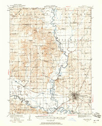 1921 Chillicothe1958 Print · USGSNorth-central Missouri at the start of the 1920s is a landscape of river-bottom farms and a bustling rail hub at the intersection of four major lines. Genealogists and researchers can trace dozens of country schoolhouses and early post offices like Hickory Creek P O, Lily Grove Church, and the Graham Mill Bridge.2 unique versions available
 - 1923 Map of Chillicothe
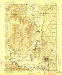 1923 Chillicothe1923 Print · USGSThe Livingston County rail hub of Chillicothe is shown here in the early twenties at the height of its regional importance. Genealogists can trace dozens of rural school districts like Happy Hollow School and early centers like Hickory P O.2 unique versions available
End of results
Showing maps 1-2 of 2
Top cities near Silverleaf
- Chillicothe historical maps
- Trenton historical maps
- Jamesport historical maps
- Breckenridge historical maps
- Galt historical maps
- Utica historical maps
See more
Frequently asked questions
- What are the different types of historical maps available for Silverleaf?
- What is the oldest map of Silverleaf?
- Where can I purchase historical maps of Silverleaf for my home or office?
- Where can I download high-res historical maps of Silverleaf?
- Are there historical topographic maps available for Silverleaf?
- Is there historical aerial imagery available for Silverleaf?
- Where are historical maps of Silverleaf sourced from?