1960s Maps of New Madrid County, Missouri
Explore 10 historic maps of New Madrid County from the 1960s. These maps offer a rare glimpse into what life looked like during the 1960s — showing old roads, neighborhoods, homes, and landmarks that have changed or disappeared over time.
Whether you're researching your family's past, planning a metal detecting trip, or studying how New Madrid County's landscape evolved across the 1960s, these high-resolution maps are a powerful tool for exploring the history of this region.
- Focus on a specific era: All maps on this page are from the 1960s, giving you a focused view of this time period.
- See what’s changed: Compare century-old streets, trails, and buildings to today's modern landscape using overlays and satellite layers.
- Research with precision: Use these maps for genealogy, historical research, land use analysis, or educational projects.
- View, download, or print: Maps are fully viewable online in high resolution, and can be downloaded or printed for your own records.
Start exploring New Madrid County's history through authentic maps from the 1960s. This is your window into the past.
New Madrid County, MO maps
(10)- 1963 Map of Morehouse, 1964 Print
 1963 Morehouse1964 Print · USGSThe Missouri Bootheel's rail and river landscape comes into focus during the early sixties, showing a region defined by agricultural drainage and competing rail lines. Trace the development of Morehouse and Canalou, or locate rural landmarks like New Bethel Ch and the Castor River.2 unique versions available
 - 1963 Map of Sikeston South, 1964 Print
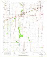
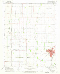
 1963 Sikeston South1964 Print · USGSThe Missouri Bootheel was undergoing significant growth in the 1960s as Sikeston expanded across the high ground of Sikeston Ridge. Genealogists and researchers can trace local landmarks like Little Vine Ch, Matthews Sch, and the St Louis - San Francisco rail corridor.3 unique versions available
 - 1963 Map of Sikeston, 1968 Print
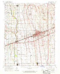 1963 Sikeston1968 Print · USGSSikeston and the surrounding Missouri lowlands are captured here in the mid-sixties, showcasing a landscape shaped by drainage engineering and railroads. Researchers can trace family sites at Silent Hill Cem, find the Pharris Ridge Sch, or locate the old Drive-in Theater.
 - 1964 Map of Tiptonville, 1965 Print
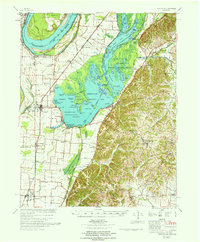
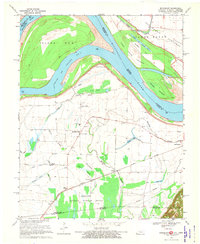
 1964 Tiptonville1965 Print · USGSTiptonville and the Mississippi River bottoms are captured in the mid-sixties, showing a landscape defined by shifting river channels and the waters of Reelfoot Lake. Genealogists can locate family sites like Cronanville Cem, Mt Zion Ch, and the Indian Mound.2 unique versions available
 - 1967 Map of Reelfoot Lake
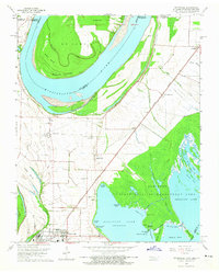
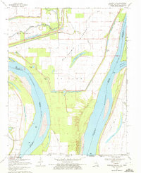
 1967 Reelfoot Lake1967 Print · USGSReelfoot Lake and the Mississippi riverfront are captured here in the mid-sixties, showing a landscape defined by wetlands and rail-line towns. Researchers can trace family sites at Owl City or Samburg, and locate landmarks like Mt Zion Ch and Oak Ridge Sch.
 - 1969 Map of East Prairie, 1971 Print
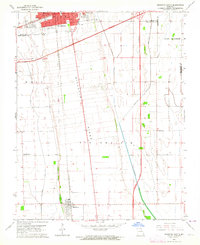
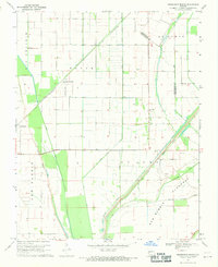
 1969 East Prairie1971 Print · USGSMissouri's Bootheel region is captured here in the late sixties, showing a landscape of productive agricultural prairies and drainage works. Genealogists and historians can trace local landmarks like Armour Cem, Bement Ch, and the schools of East Prairie.
 - 1969 Map of Henderson Mound, 1971 Print
 1969 Henderson Mound1971 Print · USGSThe Missouri Bootheel is captured here in the late sixties, showing a landscape defined by massive flood control projects and rail-line agriculture. Genealogists can locate family landmarks like Barnes Ridge Ch, Cole Cem, and the small settlement of Farrenburg.
 - 1969 Map of Hubbard Lake, 1972 Print
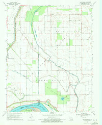
 1969 Hubbard Lake1972 Print · USGSThe Mississippi River bends through the tri-state borderlands of Missouri, Kentucky, and Tennessee during the late 1960s. Researchers can trace the legacy of river settlements and flood control through features like the Madrid Bend Ch, Adams Cem, and the massive New Madrid Levee.2 unique versions available
 - 1969 Map of Bayouville, 1972 Print
 1969 Bayouville1972 Print · USGSThe Missouri-Kentucky borderlands along the Mississippi River appear here in the late sixties, showing a landscape shaped by floodways and alluvial ponds. Genealogists can trace family roots at Pinhook, Bayouville, or Barker Cem.
 - 1969 Map of Bondurant, 1972 Print
 1969 Bondurant1972 Print · USGSThe tri-state border region of Kentucky, Missouri, and Tennessee comes alive in this late-sixties study of the Mississippi river bends. Genealogists can locate family landmarks like Sassafras Ridge Ch, Western Sch, and the Indian Mound.2 unique versions available
End of results
Showing maps 1-10 of 10
Top cities of New Madrid County
- New Madrid historical maps
- Lilbourn historical maps
- Gideon historical maps
- Morehouse historical maps
- Parma historical maps
- Matthews historical maps
See more
Frequently asked questions
- What are the different types of historical maps available for New Madrid County?
- What is the oldest map of New Madrid County?
- Where can I purchase historical maps of New Madrid County for my home or office?
- Where can I download high-res historical maps of New Madrid County?
- Are there historical topographic maps available for New Madrid County?
- Is there historical aerial imagery available for New Madrid County?
- Where are historical maps of New Madrid County sourced from?