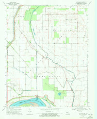
1969 Map of Bayouville
USGS Topo · Published 1972About this map
Big Oak Tree State Park anchors the lowlands of New Madrid and Mississippi counties in this late-1960s landscape, where the Mississippi River defines the border between Missouri and Kentucky. The area is marked by a complex system of drainage and flood control, including the Birds Point New Madrid Spillway, St Johns Diversion Ditch, and Wolf Hole Lateral, which manage the water levels of Tenmile Pond and Sixmile Ponds.
Find a feature on this map
29 named features on this map. Tap any name to fly to it.
Don’t see what you’re looking for? This feature index may not catch every label — zoom into the map to look around manually.
Map Details
Editions of this 1969 Bayouville Map
This is the sole edition of this map. No revisions or reprints were ever made.
Other maps of this area

1939 · Wickliffe
USGS Topo · 1:62,500

1939 · Charleston
USGS Topo · 1:62,500

1939 · Hickman
USGS Topo · 1:62,500

1939 · Bayouville
USGS Topo · 1:62,500

1951 · Bondurant
USGS Topo · 1:24,000

1951 · Hickman
USGS Topo · 1:24,000

1951 · Wolf Island
USGS Topo · 1:24,000

1951 · Wickliffe SW
USGS Topo · 1:24,000

1951 · Hubbard Lake
USGS Topo · 1:24,000

1952 · Wickliffe
USGS Topo · 1:62,500