
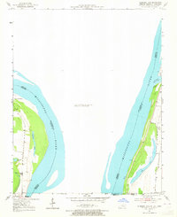
1951 Map of Hubbard Lake
USGS Topo · Published 1953About this map
Kentucky Bend defines this unique riverine landscape, where a sharp loop of the Mississippi River creates a geographic exclave of Fulton County. The terrain is marked by the shifting hydrology of the river, with oxbow remnants and backwaters such as Stonewall Lake, Washpan Lake, and Lake No 9 punctuating the low-lying alluvial plain. These water bodies, along with Elbow Slough, trace the former paths of the main channel before it migrated to its early 1950s position.
Find a feature on this map
17 named features on this map. Tap any name to fly to it.
Don’t see what you’re looking for? This feature index may not catch every label — zoom into the map to look around manually.
Map Details
Editions of this 1951 Hubbard Lake Map
2 editions found
Other maps of this area

1925 · Reelfoot Lake
USGS Topo · 1:62,500

1939 · Reelfoot Lake
USGS Topo · 1:62,500

1939 · Portageville
USGS Topo · 1:62,500

1939 · New Madrid
USGS Topo · 1:62,500

1939 · Bayouville
USGS Topo · 1:62,500

1951 · Bondurant
USGS Topo · 1:24,000

1951 · New Madrid SE
USGS Topo · 1:24,000

1954 · New Madrid
USGS Topo · 1:62,500

1955 · Portageville
USGS Topo · 1:62,500

1955 · Bayouville
USGS Topo · 1:62,500