
1939 Map of Reelfoot Lake
USGS Topo · Published 1939About this map
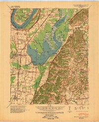
Reelfoot Lake dominates this 1930s landscape, its sprawling waters and complex network of basins like Blue Basin and Goose Basin reflecting a unique geological history in West Tennessee. The M-I-S-S-I-S-S-I-P-P-I---R-I-V-E-R forms the western boundary, with the Winchester Towhead and Donaldson Point illustrating the river's shifting nature near the Missouri border. The era's flood control infrastructure is prominent, notably the Blue Bank Levee Flood Gate near Tiptonville.
Find a feature on this map
119 named features on this map. Tap any name to fly to it.
Don’t see what you’re looking for? This feature index may not catch every label — zoom into the map to look around manually.
Map Details
Editions of this 1939 Reelfoot Lake Map
2 editions found
Other maps of this area

1925 · Reelfoot Lake
USGS Topo · 1:62,500

1939 · Portageville
USGS Topo · 1:62,500

1939 · Hickman
USGS Topo · 1:62,500

1939 · New Madrid
USGS Topo · 1:62,500

1939 · Bayouville
USGS Topo · 1:62,500

1939 · Dyersburg
USGS Topo · 1:62,500

1939 · Caruthersville
USGS Topo · 1:62,500

1950 · Obion
USGS Topo · 1:24,000

1951 · Obion
USGS Topo · 1:24,000

1951 · Bondurant
USGS Topo · 1:24,000