
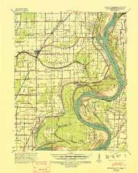
1939 Map of Portageville
USGS Topo · Published 1941About this map
The St Louis-San Francisco railroad corridors define the settlement patterns of this Missouri Bootheel landscape, linking the regional hub of Portageville to surrounding communities like De Lisle and Hayward. Located along the shifting path of the Mississippi River, the region is marked by a complex system of waterways and drainage, including Little River, Dry Bayou, and Robinson Lake. The presence of numerous rural schools, such as Grape Ridge Sch and Fisher Sch, alongside religious landmarks like Zion Rock Ch and Martins Chapel, reflects the densely populated agricultural character of the era. To the east, the river's dramatic oxbows at Little Cypress Bend and Merrivether Bend illustrate the proximity of Lake County, Tennessee, separated from Missouri by a winding state boundary that often follows old river channels and isolated landforms like Island No 14.
Find a feature on this map
55 named features on this map. Tap any name to fly to it.
Don’t see what you’re looking for? This feature index may not catch every label — zoom into the map to look around manually.
Map Details
Editions of this 1939 Portageville Map
2 editions found
Other maps of this area

1925 · Reelfoot Lake
USGS Topo · 1:62,500

1939 · Reelfoot Lake
USGS Topo · 1:62,500

1939 · New Madrid
USGS Topo · 1:62,500

1939 · Bayouville
USGS Topo · 1:62,500

1939 · Dyersburg
USGS Topo · 1:62,500

1939 · Caruthersville
USGS Topo · 1:62,500

1940 · Malden
USGS Topo · 1:62,500

1940 · Pascola
USGS Topo · 1:62,500

1940 · Hayti
USGS Topo · 1:62,500

1951 · New Madrid SE
USGS Topo · 1:24,000