1920s Maps of Nodaway County, Missouri
Explore 3 historic maps of Nodaway County from the 1920s. These maps offer a rare glimpse into what life looked like during the 1920s — showing old roads, neighborhoods, homes, and landmarks that have changed or disappeared over time.
Whether you're researching your family's past, planning a metal detecting trip, or studying how Nodaway County's landscape evolved across the 1920s, these high-resolution maps are a powerful tool for exploring the history of this region.
- Focus on a specific era: All maps on this page are from the 1920s, giving you a focused view of this time period.
- See what’s changed: Compare century-old streets, trails, and buildings to today's modern landscape using overlays and satellite layers.
- Research with precision: Use these maps for genealogy, historical research, land use analysis, or educational projects.
- View, download, or print: Maps are fully viewable online in high resolution, and can be downloaded or printed for your own records.
Start exploring Nodaway County's history through authentic maps from the 1920s. This is your window into the past.
Nodaway County, MO maps
(3)- 1925 Map of Stanberry
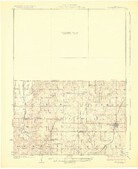 1925 Stanberry1925 Print · USGSNorthwest Missouri in the mid-1920s is captured here at a height of rural community life before the consolidation of rural districts. Genealogists can locate dozens of localized landmarks like Bachelor Hall School, Flag Springs, and the Chicago Burlington and Quincy railroad line.3 unique versions available
 - 1926 Map of Maitland
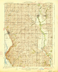 1926 Maitland1926 Print · USGSNorthwest Missouri in the mid-1920s reveals a countryside of small farms and tightly packed rural school districts. Genealogists and historians can trace family roots through dozens of local landmarks like Triumph School, Bethel Church, and the village of Graham.3 unique versions available
 - 1927 Map of Bolckow
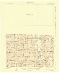 1927 Bolckow1927 Print · USGSNorthwest Missouri thrived as a rail-centered farming region in the years before the Great Depression. Researchers can trace rural lineages through numerous country schools like Radical School and Gravel Wall School, or locate the Stone Church Cem.2 unique versions available
End of results
Showing maps 1-3 of 3
Frequently asked questions
- What are the different types of historical maps available for Nodaway County?
- What is the oldest map of Nodaway County?
- Where can I purchase historical maps of Nodaway County for my home or office?
- Where can I download high-res historical maps of Nodaway County?
- Are there historical topographic maps available for Nodaway County?
- Is there historical aerial imagery available for Nodaway County?
- Where are historical maps of Nodaway County sourced from?