1930s Maps of Nodaway County, Missouri
Explore 2 historic maps of Nodaway County from the 1930s. These maps offer a rare glimpse into what life looked like during the 1930s — showing old roads, neighborhoods, homes, and landmarks that have changed or disappeared over time.
Whether you're researching your family's past, planning a metal detecting trip, or studying how Nodaway County's landscape evolved across the 1930s, these high-resolution maps are a powerful tool for exploring the history of this region.
- Focus on a specific era: All maps on this page are from the 1930s, giving you a focused view of this time period.
- See what’s changed: Compare century-old streets, trails, and buildings to today's modern landscape using overlays and satellite layers.
- Research with precision: Use these maps for genealogy, historical research, land use analysis, or educational projects.
- View, download, or print: Maps are fully viewable online in high resolution, and can be downloaded or printed for your own records.
Start exploring Nodaway County's history through authentic maps from the 1930s. This is your window into the past.
Nodaway County, MO maps
(2)- 1939 Map of Skidmore
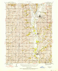 1939 Skidmore1939 Print · USGSNorthwest Missouri is captured here in the late thirties, when the river valleys were teeming with small school districts and active rail lines. Researchers can trace family history through dozens of rural schools like Evans Sch and churches including Centenary Ch.3 unique versions available
 - 1939 Map of Stanberry, 1954 Print
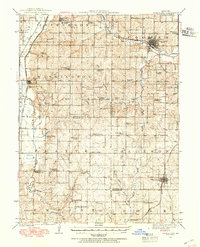 1939 Stanberry1954 Print · USGSNorthwest Missouri thrived as a rail and agricultural hub in the late thirties, with three major lines intersecting the fertile prairie. Genealogists can trace family roots through dozens of local landmarks like Conception College, Stanberry, and the Meekers Cem.
End of results
Showing maps 1-2 of 2
Frequently asked questions
- What are the different types of historical maps available for Nodaway County?
- What is the oldest map of Nodaway County?
- Where can I purchase historical maps of Nodaway County for my home or office?
- Where can I download high-res historical maps of Nodaway County?
- Are there historical topographic maps available for Nodaway County?
- Is there historical aerial imagery available for Nodaway County?
- Where are historical maps of Nodaway County sourced from?