1950s Maps of Perry County, Missouri
Explore 11 historic maps of Perry County from the 1950s. These maps offer a rare glimpse into what life looked like during the 1950s — showing old roads, neighborhoods, homes, and landmarks that have changed or disappeared over time.
Whether you're researching your family's past, planning a metal detecting trip, or studying how Perry County's landscape evolved across the 1950s, these high-resolution maps are a powerful tool for exploring the history of this region.
- Focus on a specific era: All maps on this page are from the 1950s, giving you a focused view of this time period.
- See what’s changed: Compare century-old streets, trails, and buildings to today's modern landscape using overlays and satellite layers.
- Research with precision: Use these maps for genealogy, historical research, land use analysis, or educational projects.
- View, download, or print: Maps are fully viewable online in high resolution, and can be downloaded or printed for your own records.
Start exploring Perry County's history through authentic maps from the 1950s. This is your window into the past.
Perry County, MO maps
(11)- 1950 Map of Paducah
 1950 Paducah1950 Print · USGSThe confluence of the great midwestern rivers defines this mid-century landscape at the intersection of Illinois, Kentucky, and Missouri. Genealogists and historians can trace the rail-and-river economy through the hubs of Paducah, Cairo, and Metropolis or locate family roots near the Wildcat Hills.
 - 1953 Map of Rolla
 1953 Rolla1953 Print · USGSSoutheast Missouri’s mining towns and timberlands are seen here at the start of the 1950s. Genealogists and historians can trace the rail-and-river economy through local hubs like Fredericktown and the lead-mining heritage of Potosi and Desloge.
 - 1954 Map of Paducah
 1954 Paducah1954 Print · USGSSouthern Illinois and Western Kentucky intersect at the great river confluences during this mid-century era of rail and river industry. Genealogists and historians can trace family roots and commerce through river towns like Cairo, Metropolis, and Golconda, or along the tracks of the Illinois Central Railroad.2 unique versions available
 - 1954 Map of Rolla, 1970 Print
 1954 Rolla1970 Print · USGSThe Missouri Ozarks and the historic Lead Belt are captured in the late sixties, showing a landscape of deep river hollows and industrial mines. Researchers can trace the routes of the Missouri Pacific RR to extraction sites like the Iron Mountain Mine or Pea Ridge Mine.2 unique versions available
 - 1958 Map of Rolla
 1958 Rolla1958 Print · USGSThe Missouri Ozarks and the lead-rich hills of the southeast are captured here in the late fifties as timber and mining shaped the local economy. Researchers can locate family landmarks like the Rolla Cemetery or trace old rail lines including the Missouri-Illinois RR and St Louis-San Francisco RR.
 - 1959 Map of Rolla
 1959 Rolla1959 Print · USGSMid-century Missouri is defined here by the deep forests of the Ozarks and the industrial peaks of the St Francois Mountains. Genealogists and historians can trace the development of towns like Potosi and Fredericktown or locate rural landmarks like Dry Fork Church and the Phelps County Courthouse.
 - 1959 Map of Patton, 1960 Print
 1959 Patton1960 Print · USGSBollinger County in the late fifties shows a rural network of river-valley farms and forest boundaries. Genealogists can locate family landmarks like Oak Grove School, the Yount Cemetery, and local congregations at Bethel Church and Reagan Chapel.2 unique versions available
 - 1959 Map of Parker Lake, 1960 Print
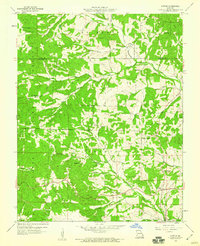
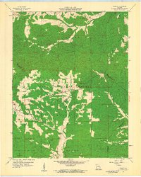
 1959 Parker Lake1960 Print · USGSPerry County and the surrounding Ozark hills are captured here in the late fifties, showing a landscape of forest ridges and creek-bottom homesteads. Genealogists can trace family footprints near Baudendistel Sch, Whitewater Ch, and Parker Lake.3 unique versions available
 - 1959 Map of Higdon, 1960 Print
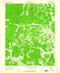
 1959 Higdon1960 Print · USGSThe rural borderlands of Madison, Perry, and Bollinger counties are captured here in the late fifties, defined by the winding Castor River and Whitewater River. Genealogists and historians can locate old mill sites like Hahns Mill, numerous country schools including Walnut Grove Sch, and family burial grounds like Underwood Cem.2 unique versions available
 - 1959 Map of Higdon, 1960 Print
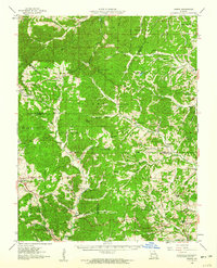
 1959 Higdon1960 Print · USGSMadison County's forested river valleys are captured here in the late fifties, showing a landscape of remote settlements and timbered hills. Genealogists and historians can trace family locations through Hahns Mill, Underwood Cem, and the Missouri Pacific rail siding at Cornwall.3 unique versions available
 - 1959 Map of Womack, 1960 Print
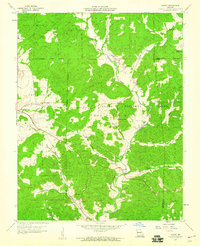
 1959 Womack1960 Print · USGSSoutheast Missouri’s forested hills and river headwaters are captured in the late fifties as rural life revolved around remote schoolhouses and forest lookouts. Researchers can trace family sites at McDowell Cem or locate community centers like Womack and Crossroads Sch.4 unique versions available
End of results
Showing maps 1-11 of 11
Top cities of Perry County
Frequently asked questions
- What are the different types of historical maps available for Perry County?
- What is the oldest map of Perry County?
- Where can I purchase historical maps of Perry County for my home or office?
- Where can I download high-res historical maps of Perry County?
- Are there historical topographic maps available for Perry County?
- Is there historical aerial imagery available for Perry County?
- Where are historical maps of Perry County sourced from?