1950s Maps of Doolittle, Missouri
Explore 8 historic maps of Doolittle from the 1950s. These maps offer a rare glimpse into what life looked like during the 1950s — showing old roads, neighborhoods, homes, and landmarks that have changed or disappeared over time.
Whether you're researching your family's past, planning a metal detecting trip, or studying how Doolittle's landscape evolved across the 1950s, these high-resolution maps are a powerful tool for exploring the history of this region.
- Focus on a specific era: All maps on this page are from the 1950s, giving you a focused view of this time period.
- See what’s changed: Compare century-old streets, trails, and buildings to today's modern landscape using overlays and satellite layers.
- Research with precision: Use these maps for genealogy, historical research, land use analysis, or educational projects.
- View, download, or print: Maps are fully viewable online in high resolution, and can be downloaded or printed for your own records.
Start exploring Doolittle's history through authentic maps from the 1950s. This is your window into the past.
Doolittle, MO maps
(8)- 1950 Map of Newburg, 1957 Print
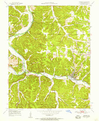 1950 Newburg1957 Print · USGSMid-century Phelps County comes to life along the river bends and rail lines during the early 1950s. Genealogists and historians can locate family landmarks such as Kitchell Cem and Hickory Point Sch, or trace the old paths of Boulware Ford and U.S. 66.4 unique versions available
 - 1951 Map of Rolla
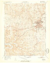 1951 Rolla1951 Print · USGSRolla and the surrounding Phelps County hills are shown here just after mid-century, centered on the growing campus of the Missouri School of Mines. Genealogists and researchers can trace old family landmarks like Strawhun Sch, Hirsche Sch, and the Beaver Creek Mine along the winding Ozark creeks.3 unique versions available
 - 1951 Map of Newburg
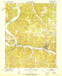 1951 Newburg1951 Print · USGSThe Phelps County river country is captured here in the early fifties, centering on the rail hub of Newburg. Genealogists and historians can trace the foundations of local life through rural landmarks like Kitchell Cem, Hickory Point Sch, and the riverside settlement of Jerome.
 - 1951 Map of Rolla, 1958 Print
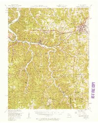 1951 Rolla1958 Print · USGSMid-century Phelps County centers on the growing hub of Rolla and the transit corridors of Route 66 and the St Louis-San Francisco railroad. Genealogists can trace family landmarks like New Rome Church, Yancy Mills Post Office, and the Light Cemetery.3 unique versions available
 - 1953 Map of Rolla
 1953 Rolla1953 Print · USGSSoutheast Missouri’s mining towns and timberlands are seen here at the start of the 1950s. Genealogists and historians can trace the rail-and-river economy through local hubs like Fredericktown and the lead-mining heritage of Potosi and Desloge.
 - 1954 Map of Rolla, 1970 Print
 1954 Rolla1970 Print · USGSThe Missouri Ozarks and the historic Lead Belt are captured in the late sixties, showing a landscape of deep river hollows and industrial mines. Researchers can trace the routes of the Missouri Pacific RR to extraction sites like the Iron Mountain Mine or Pea Ridge Mine.2 unique versions available
 - 1958 Map of Rolla
 1958 Rolla1958 Print · USGSThe Missouri Ozarks and the lead-rich hills of the southeast are captured here in the late fifties as timber and mining shaped the local economy. Researchers can locate family landmarks like the Rolla Cemetery or trace old rail lines including the Missouri-Illinois RR and St Louis-San Francisco RR.
 - 1959 Map of Rolla
 1959 Rolla1959 Print · USGSMid-century Missouri is defined here by the deep forests of the Ozarks and the industrial peaks of the St Francois Mountains. Genealogists and historians can trace the development of towns like Potosi and Fredericktown or locate rural landmarks like Dry Fork Church and the Phelps County Courthouse.
End of results
Showing maps 1-8 of 8
Top cities near Doolittle
- Rolla historical maps
- Saint Robert historical maps
- St. James historical maps
- Dixon historical maps
- Newburg historical maps
- Powellville historical maps
Frequently asked questions
- What are the different types of historical maps available for Doolittle?
- What is the oldest map of Doolittle?
- Where can I purchase historical maps of Doolittle for my home or office?
- Where can I download high-res historical maps of Doolittle?
- Are there historical topographic maps available for Doolittle?
- Is there historical aerial imagery available for Doolittle?
- Where are historical maps of Doolittle sourced from?