1940s Maps of Pike County, Missouri
Explore 10 historic maps of Pike County from the 1940s. These maps offer a rare glimpse into what life looked like during the 1940s — showing old roads, neighborhoods, homes, and landmarks that have changed or disappeared over time.
Whether you're researching your family's past, planning a metal detecting trip, or studying how Pike County's landscape evolved across the 1940s, these high-resolution maps are a powerful tool for exploring the history of this region.
- Focus on a specific era: All maps on this page are from the 1940s, giving you a focused view of this time period.
- See what’s changed: Compare century-old streets, trails, and buildings to today's modern landscape using overlays and satellite layers.
- Research with precision: Use these maps for genealogy, historical research, land use analysis, or educational projects.
- View, download, or print: Maps are fully viewable online in high resolution, and can be downloaded or printed for your own records.
Start exploring Pike County's history through authentic maps from the 1940s. This is your window into the past.
Pike County, MO maps
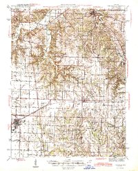
(10)- 1940 Map of Bowling Green
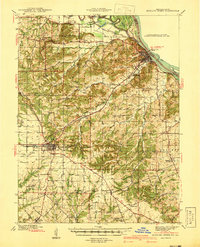 1940 Bowling Green1940 Print · USGSPike County at the end of the Depression reveals a landscape tied to the Mississippi River and a thriving rail network. Genealogists can trace family roots through dozens of rural landmarks like St Clement, Stark Nursery, and the Noix Creek Cem.2 unique versions available
 - 1942 Map of Nebo
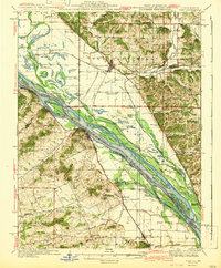 1942 Nebo1942 Print · USGSThe Mississippi River floodplain and the rising knobs of Missouri appear here as they were in the early 1940s. Genealogists can trace a dense network of rural landmarks, from Salem Sch and Corinth Ch to the riverfront at Clarksville and Annada.2 unique versions available
 - 1942 Map of Elsberry
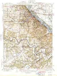
 1942 Elsberry1942 Print · USGSNortheastern Missouri's river bluffs and rail corridors are captured here during the early 1940s. Genealogists and historians can locate vanished landmarks like Brussels Sch, Penn Cave, and the rural Old Alexandria Ch.2 unique versions available
 - 1942 Map of Bellflower, 1966 Print
 1942 Bellflower1966 Print · USGSEastern Missouri farm country is captured here during the early years of the war, revealing a landscape defined by the Cuivre River and the Chicago Burlington and Quincy rail line. Genealogists can locate family-named landmarks and rural hubs like Middletown, Smyrna Ch, and the Prairie Flower Sch.
 - 1943 Map of Vandalia, 1972 Print
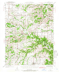
 1943 Vandalia1972 Print · USGSMissouri's rural heartland is captured here in the 1940s at the junction of Audrain, Pike, and Ralls Counties. Genealogists can trace dozens of rural schoolhouses and churches, including Round Grove Sch, Elm Grove Ch, and the settlement of Madisonville.
 - 1944 Map of Barry
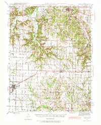
 1944 Barry1944 Print · USGSPike County's river-bottoms and bluffs are captured here in the mid-1940s, showing the complex interaction between the river and the rail lines. Genealogists and local historians can trace rural school locations like Wilke Chapel Sch and Buckeye Sch, or explore old landings such as Cincinnati Landing.2 unique versions available
 - 1945 Map of Bellflower
 1945 Bellflower1945 Print · USGSThe rural borderlands of Montgomery, Audrain, and Pike counties are captured here in the mid-1940s as a network of tightly-knit farming communities. Genealogists can trace family footprints through dozens of local landmarks, including Payne Cem, Smyrna Ch, and the many namesake schoolhouses like Mudd Sch.2 unique versions available
 - 1945 Map of Hannibal
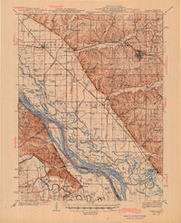
 1945 Hannibal1945 Print · USGSMid-century Hannibal is captured here as a bustling Mississippi river port and railroad crossroads just after the war. Local historians can trace family roots through dozens of rural landmarks like Mt Zion Cem, Withers Mill, and Ocean Wave Sch.2 unique versions available
 - 1945 Map of Vandalia
 1945 Vandalia1945 Print · USGSMid-century Audrain and Pike Counties are shown here at a peak of rural settlement, centered on the rail hub of Vandalia. Genealogists can locate dozens of country schools and churches, from New Michigan Sch to Mt Air Ch and Spencerburg.3 unique versions available
 - 1948 Map of Quincy
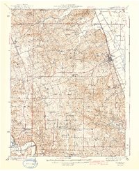
 1948 Quincy1948 Print · USGSThe Mississippi and Illinois River valleys are captured at a post-war crossroads as rail and river travel met the expanding highway system. Genealogists can trace family settlements from Quincy to Hannibal and smaller towns like Vandalia and Jerseyville.2 unique versions available
End of results
Showing maps 1-10 of 10
Top cities of Pike County
- Bowling Green historical maps
- Louisiana historical maps
- Clarksville historical maps
- Eolia historical maps
- Frankford historical maps
- Curryville historical maps
See more
Frequently asked questions
- What are the different types of historical maps available for Pike County?
- What is the oldest map of Pike County?
- Where can I purchase historical maps of Pike County for my home or office?
- Where can I download high-res historical maps of Pike County?
- Are there historical topographic maps available for Pike County?
- Is there historical aerial imagery available for Pike County?
- Where are historical maps of Pike County sourced from?