1950s Maps of Platte County, Missouri
Explore 22 historic maps of Platte County from the 1950s. These maps offer a rare glimpse into what life looked like during the 1950s — showing old roads, neighborhoods, homes, and landmarks that have changed or disappeared over time.
Whether you're researching your family's past, planning a metal detecting trip, or studying how Platte County's landscape evolved across the 1950s, these high-resolution maps are a powerful tool for exploring the history of this region.
- Focus on a specific era: All maps on this page are from the 1950s, giving you a focused view of this time period.
- See what’s changed: Compare century-old streets, trails, and buildings to today's modern landscape using overlays and satellite layers.
- Research with precision: Use these maps for genealogy, historical research, land use analysis, or educational projects.
- View, download, or print: Maps are fully viewable online in high resolution, and can be downloaded or printed for your own records.
Start exploring Platte County's history through authentic maps from the 1950s. This is your window into the past.
Platte County, MO maps
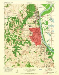
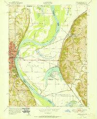
(22)- 1950 Map of Kansas City
 1950 Kansas City1950 Print · USGSMid-century Kansas and Missouri are captured here during a period of industrial growth and shifting transportation. Genealogists and historians can trace rail lines like the Wabash RR or locate ancestral homes near the Potawatomi Indian Reservation and Horton.
 - 1950 Map of Nashua
 1950 Nashua1950 Print · USGSClay and Platte Counties are captured here in the late 1940s, showing a landscape of rural school districts and small crossroads towns. Researchers can trace family ties through community hubs like Nashua, Mt Olivet Church, and the Lone Star School.
 - 1950 Map of Ferrelview
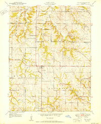
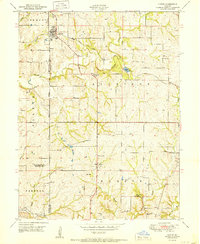
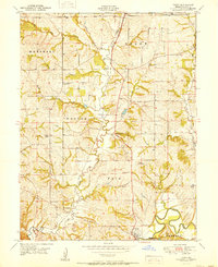
 1950 Ferrelview1950 Print · USGSMid-century Platte County is captured here as a landscape of small farming communities and country schools. Genealogists can locate family-named landmarks like Waller Cemetery and Pancake Cemetery or trace the early foundations of Ferrelview and Linkville.2 unique versions available
 - 1950 Map of Platte City
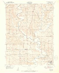
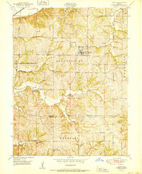
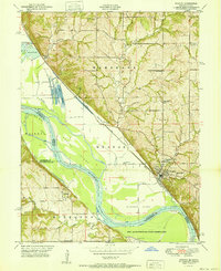
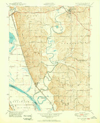 1950 Platte City1950 Print · USGSThe confluence of the Missouri and Platte Rivers at the mid-century reveals a landscape of fertile bottomlands and winding oxbows. Genealogists and historians can trace numerous rural sites like the Kansas State Penitentiary Farm, Hillsboro Church, and Hackberry School.2 unique versions available
 - 1950 Map of Smithville
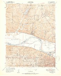
 1950 Smithville1950 Print · USGSThe rural borderlands of Platte, Clay, and Clinton counties are shown here just after the war, defined by the winding Platte River and a network of small farm towns. Researchers can trace the locations of dozens of vanished schools and cemeteries, from the Masonic Cemetery to the South Gale School and the historic Covered Bridge.2 unique versions available
 - 1951 Map of Smithville
 1951 Smithville1951 Print · USGSNorth of Kansas City in the early 1950s, this area shows a landscape of river-valley farms and small rural settlements. Researchers can locate numerous one-room schoolhouses like Rocky Point School and trace family-named landmarks such as Reed Cemetery and Rice Bridge.2 unique versions available
 - 1951 Map of Edgerton
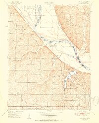
 1951 Edgerton1951 Print · USGSNorthwest Missouri at the mid-century mark reveals a landscape defined by the winding Platte River and its many tributaries. Researchers can locate numerous local landmarks like Union Mill Cem, Arnoldsville School, and Davis Chapel as they appeared before modern development.2 unique versions available
 - 1951 Map of Leavenworth
 1951 Leavenworth1951 Print · USGSLeavenworth and the Missouri River corridor are captured here during the post-war era of military and institutional expansion. Genealogists and historians can trace the footprint of Fort Leavenworth, locate rural schools like Glen Valley School, and identify family plots in Greenwood Cemetery.2 unique versions available
 - 1951 Map of Parkville
 1951 Parkville1951 Print · USGSMid-century development straddles the Missouri River between Platte and Wyandotte counties as suburban growth reaches the river bluffs. Researchers can trace historic institutions like Park College and Western University alongside many local burial grounds like St Marys Cemetery.2 unique versions available
 - 1951 Map of Wolcott
 1951 Wolcott1951 Print · USGSThe Missouri River bottoms and Kansas bluffs come into focus in the early 1950s, showing a landscape of river bends and rural crossroads. Genealogists can trace family landmarks like the Dungan Cemetery or historic schools including Pleasant Ridge School and District No 45 School.
 - 1951 Map of Oak Mills
 1951 Oak Mills1951 Print · USGSThe Missouri River borderlands come alive in the early fifties, showing the rural communities of Atchison and Leavenworth counties. Trace local family history through landmarks like Round Prairie Church, Dalbey, and the historic Millwood settlement.2 unique versions available
 - 1951 Map of De Kalb
 1951 De Kalb1951 Print · USGSNorthwest Missouri's rural township structure is vividly detailed here in the early fifties, just as the traditional network of country schools remained intact. You can trace early homesteads and local heritage through numerous landmarks like DeKalb, Mock Corner, and Forest Valley School.2 unique versions available
 - 1951 Map of Gower
 1951 Gower1951 Print · USGSGower and the surrounding Missouri townships appear here in the early fifties, showing a rural landscape organized by rail and stream. Genealogists can trace family names through landmarks like Allen Cem, Mt Carmel School, and Grayson.2 unique versions available
 - 1951 Map of Dearborn
 1951 Dearborn1951 Print · USGSMissouri's rural borderlands between Buchanan and Platte counties come to life in the early fifties, following the rail and road corridors. Genealogists can trace family names through numerous rural burial grounds like Judy Cem and Dearborn Masonic Cem.2 unique versions available
 - 1951 Map of Leavenworth
 1951 Leavenworth1951 Print · USGSLeavenworth and the Missouri River borderlands are shown here in the early Cold War era, marked by significant federal and military installations. Trace the footprints of Fort Leavenworth, Sherman Air Force Base, and rural landmarks like the Fancy Bottoms School.2 unique versions available
 - 1951 Map of Tracy
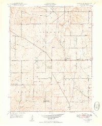
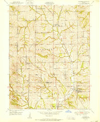
 1951 Tracy1951 Print · USGSPlatte County at the start of the 1950s was a landscape defined by its river bends and small rural schoolhouses. Genealogists can locate family-named sites like Wilkerson Cemetery or trace the old paths of the Chicago Bee Line railroad near Tracy.2 unique versions available
 - 1951 Map of Camden Point
 1951 Camden Point1951 Print · USGSNorthern Platte County in the early fifties shows a landscape of river-bend farms and rural townships. Trace family roots at Standiford Cem or find old school sites like Franklin Sch and the community at Camden Point.2 unique versions available
 - 1951 Map of Weston
 1951 Weston1951 Print · USGSThe Missouri-Kansas borderlands come to life in this mid-century survey, showing the river winding past Weston and the northern edge of the Fort Leavenworth Military Reservation. Genealogists can locate family landmarks like Laurel Hill Cemetery and rural schools including Fancy Bottoms School and Burrus School.2 unique versions available
 - 1951 Map of North Kansas City
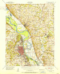
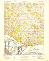 1951 North Kansas City1951 Print · USGSThe Kansas City riverfront was a bustling hub of rail and aviation activity in the early fifties. Genealogists and local historians can trace family roots through landmarks like Quindaro, the Dunbar School, and the historic Antioch Church.2 unique versions available
 - 1951 Map of Rushville
 1951 Rushville1951 Print · USGSThe Missouri River floodplain near Atchison and Rushville is shown here in the early fifties, highlighting a landscape shaped by massive river bends and rail lines. Genealogists can trace family names at Armstrong Cem and locate rural landmarks like Pleasant Valley School or the State Orphan Home.2 unique versions available
 - 1954 Map of Kansas City
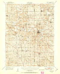
 1954 Kansas City1954 Print · USGSThe Missouri-Kansas borderlands flourished in the post-war era as river commerce and rail networks converged at the Missouri River. Genealogists and historians can trace the foundations of Kansas City and smaller rural hubs like Hiawatha or Sabetha.
 - 1956 Map of Kansas City, 1967 Print
 1956 Kansas City1967 Print · USGSThe Kansas-Missouri border region thrived during the mid-fifties, centered on the growing metropolitan cores and the busy river valleys. Researchers can trace the layout of significant government sites like Fort Leavenworth and the Lake City Army Ammunition Plant.4 unique versions available
End of results
Showing maps 1-22 of 22
Top cities of Platte County
- Parkville historical maps
- Platte City historical maps
- Riverside historical maps
- Weatherby Lake historical maps
- Weston historical maps
- Lake Waukomis historical maps
See more
Frequently asked questions
- What are the different types of historical maps available for Platte County?
- What is the oldest map of Platte County?
- Where can I purchase historical maps of Platte County for my home or office?
- Where can I download high-res historical maps of Platte County?
- Are there historical topographic maps available for Platte County?
- Is there historical aerial imagery available for Platte County?
- Where are historical maps of Platte County sourced from?