1960s Maps of Edgerton, Missouri
Explore 5 historic maps of Edgerton from the 1960s. These maps offer a rare glimpse into what life looked like during the 1960s — showing old roads, neighborhoods, homes, and landmarks that have changed or disappeared over time.
Whether you're researching your family's past, planning a metal detecting trip, or studying how Edgerton's landscape evolved across the 1960s, these high-resolution maps are a powerful tool for exploring the history of this region.
- Focus on a specific era: All maps on this page are from the 1960s, giving you a focused view of this time period.
- See what’s changed: Compare century-old streets, trails, and buildings to today's modern landscape using overlays and satellite layers.
- Research with precision: Use these maps for genealogy, historical research, land use analysis, or educational projects.
- View, download, or print: Maps are fully viewable online in high resolution, and can be downloaded or printed for your own records.
Start exploring Edgerton's history through authentic maps from the 1960s. This is your window into the past.
Edgerton, MO maps
(5)- 1960 Map of Kansas City
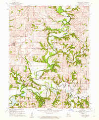
 1960 Kansas City1960 Print · USGSMid-century Kansas and Missouri meet at the river forks, showing a sprawling rail-and-river economy during the 1950s growth era. Genealogists and researchers can trace tribal lands like the Kickapoo Indian Reservation or follow the early interstate corridors through Saint Joseph and Independence.3 unique versions available
 - 1961 Map of Smithville, 1962 Print
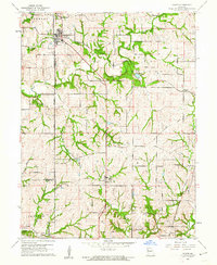
 1961 Smithville1962 Print · USGSNorth of Kansas City in the early sixties, this area shows a landscape of river-bottom settlements and emerging wildlife management. Trace local genealogy and infrastructure through Reed Cem, the Old Railroad Grade, and the small communities of Mecca and Paradise.3 unique versions available
 - 1961 Map of Gower, 1962 Print
 1961 Gower1962 Print · USGSClinton and Buchanan Counties come alive in the early sixties as rural crossroads and family homesteads define the landscape. Trace ancestral roots at Antioch Cem or follow the path of commerce along the Old Railroad Grade and Castile Creek.2 unique versions available
 - 1961 Map of Camden Point, 1962 Print
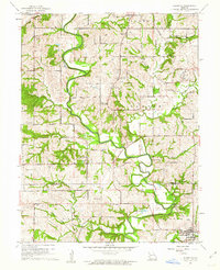
 1961 Camden Point1962 Print · USGSPlatte County in the early sixties reveals a landscape where the Platte River meanders through agricultural townships. Genealogists and historians can trace an Old Railroad Grade and locate numerous family burial sites like McComas Cem and Smith Cem.2 unique versions available
 - 1961 Map of Edgerton, 1962 Print
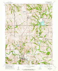
 1961 Edgerton1962 Print · USGSThe Missouri countryside north of Kansas City was a landscape of river levees and rail remnants in the early sixties. Researchers can trace the old railroad grade near Edgerton and locate numerous family burial sites like Maupin Cem and Brinton Cem.2 unique versions available
End of results
Showing maps 1-5 of 5
Top cities near Edgerton
- Kansas City historical maps
- Saint Joseph historical maps
- Liberty historical maps
- Smithville historical maps
- Platte City historical maps
- Plattsburg historical maps
See more
Frequently asked questions
- What are the different types of historical maps available for Edgerton?
- What is the oldest map of Edgerton?
- Where can I purchase historical maps of Edgerton for my home or office?
- Where can I download high-res historical maps of Edgerton?
- Are there historical topographic maps available for Edgerton?
- Is there historical aerial imagery available for Edgerton?
- Where are historical maps of Edgerton sourced from?