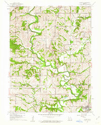
1961 Map of Edgerton
USGS Topo · Published 1962About this map
The Platte River meanders through this portion of Missouri, defining the landscape across the Buchanan Co Platte Co line. Near the settlement of Edgerton, the river corridor is protected by a system of levees, while the surrounding uplands are marked by an intricate network of creeks like Castile Creek and Wolfpen Creek. This 1961 revision documents a rural economy transitioning from early infrastructure, notably visible in the old railroad grade that once connected these farming communities.
Find a feature on this map
36 named features on this map. Tap any name to fly to it.
Don’t see what you’re looking for? This feature index may not catch every label — zoom into the map to look around manually.
Map Details
Editions of this 1961 Edgerton Map
2 editions found
Other maps of this area

1890 · Kansas City
USGS Topo · 1:125,000

1894 · Kansas City
USGS Topo · 1:125,000

1910 · Leavenworth
USGS Topo · 1:62,500

1914 · Smithville
USGS Topo · 1:62,500

1925 · Gower
USGS Topo · 1:62,500

1927 · Dearborn
USGS Topo · 1:62,500

1948 · Leavenworth
USGS Topo · 1:62,500

1950 · Kansas City
USGS Topo · 1:250,000
1950 · Smithville
USGS Topo · 1:62,500
1951 · Smithville
USGS Topo · 1:24,000