1940s Maps of Houston Lake, Missouri
Explore 4 historic maps of Houston Lake from the 1940s. These maps offer a rare glimpse into what life looked like during the 1940s — showing old roads, neighborhoods, homes, and landmarks that have changed or disappeared over time.
Whether you're researching your family's past, planning a metal detecting trip, or studying how Houston Lake's landscape evolved across the 1940s, these high-resolution maps are a powerful tool for exploring the history of this region.
- Focus on a specific era: All maps on this page are from the 1940s, giving you a focused view of this time period.
- See what’s changed: Compare century-old streets, trails, and buildings to today's modern landscape using overlays and satellite layers.
- Research with precision: Use these maps for genealogy, historical research, land use analysis, or educational projects.
- View, download, or print: Maps are fully viewable online in high resolution, and can be downloaded or printed for your own records.
Start exploring Houston Lake's history through authentic maps from the 1940s. This is your window into the past.
Houston Lake, MO maps
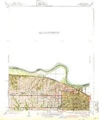
(4)- 1940 Map of North Kansas City
 1940 North Kansas City1940 Print · USGSThe industrial riverfront and Clay County uplands are documented here during the mid-1930s as the regional transport network matured. Genealogists and researchers can locate family landmarks like New Stark Cem, Bethel Ch, and the many rural schoolhouses serving Gashland and Barry.2 unique versions available
 - 1943 Map of Quindaro
 1943 Quindaro1943 Print · USGSThe Missouri-Kansas borderlands in the 1940s reveal a landscape of expanding schools and electric transit. Trace the routes of the Kansas City and Leavenworth Electric Road and find sites like Nearman Sch and Memorial Park Cemetery.
 - 1948 Map of North Kansas City, 1958 Print
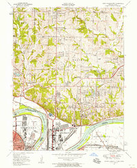 1948 North Kansas City1958 Print · USGSNorth Kansas City and the Missouri River corridor show a bustling mid-century mix of aviation, industry, and early suburban growth. Trace the development of Quindaro, the operations at Fairfax Airport, and local roots at Faubion Cemetery.
 - 1948 Map of Parkville, 1959 Print
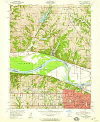 1948 Parkville1959 Print · USGSThe Missouri River state line near Parkville comes alive in the late 1940s as post-war suburban growth meets historic riverfront industry. Researchers can trace early family sites from St Marys Cemetery to the campus of Park College and the old Western University site.
End of results
Showing maps 1-4 of 4
Top cities near Houston Lake
- Kansas City historical maps
- Overland Park historical maps
- Kansas City historical maps
- Olathe historical maps
- Independence historical maps
- Lee's Summit historical maps
See more
Frequently asked questions
- What are the different types of historical maps available for Houston Lake?
- What is the oldest map of Houston Lake?
- Where can I purchase historical maps of Houston Lake for my home or office?
- Where can I download high-res historical maps of Houston Lake?
- Are there historical topographic maps available for Houston Lake?
- Is there historical aerial imagery available for Houston Lake?
- Where are historical maps of Houston Lake sourced from?