1960s Maps of Weston, Missouri
Explore 4 historic maps of Weston from the 1960s. These maps offer a rare glimpse into what life looked like during the 1960s — showing old roads, neighborhoods, homes, and landmarks that have changed or disappeared over time.
Whether you're researching your family's past, planning a metal detecting trip, or studying how Weston's landscape evolved across the 1960s, these high-resolution maps are a powerful tool for exploring the history of this region.
- Focus on a specific era: All maps on this page are from the 1960s, giving you a focused view of this time period.
- See what’s changed: Compare century-old streets, trails, and buildings to today's modern landscape using overlays and satellite layers.
- Research with precision: Use these maps for genealogy, historical research, land use analysis, or educational projects.
- View, download, or print: Maps are fully viewable online in high resolution, and can be downloaded or printed for your own records.
Start exploring Weston's history through authentic maps from the 1960s. This is your window into the past.
Weston, MO maps
(4)- 1960 Map of Kansas City
 1960 Kansas City1960 Print · USGSMid-century Kansas and Missouri meet at the river forks, showing a sprawling rail-and-river economy during the 1950s growth era. Genealogists and researchers can trace tribal lands like the Kickapoo Indian Reservation or follow the early interstate corridors through Saint Joseph and Independence.3 unique versions available
 - 1961 Map of Weston, 1962 Print
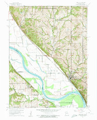 1961 Weston1962 Print · USGSThe Missouri River floodplain near the Kansas-Missouri border was a hive of rail and river activity in the early 1960s. Genealogists and historians can trace local landmarks like Graceland Cem, the Chicago Burlington and Quincy rail line, and the riverside community of Weston.3 unique versions available
 - 1961 Map of Platte City, 1962 Print
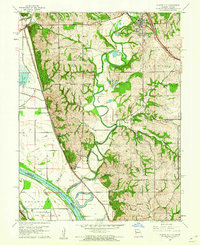 1961 Platte City1962 Print · USGSThe Missouri-Kansas borderlands in the early sixties reveal a landscape of river bends and railroad towns. Genealogists and historians can trace family-named sites like Jewett Cem or visit the rural Hickory Grove Ch and the Kansas State Penitentiary Farm.4 unique versions available
 - 1961 Map of Tracy, 1962 Print
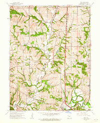 1961 Tracy1962 Print · USGSPlatte County in the early sixties was a landscape of river-valley agriculture and small rail stops along the Chicago Great Western. Researchers can trace the layout of Platte City, find rural burial sites like Wilkerson Cem, and locate settlements like Settles Station.2 unique versions available
End of results
Showing maps 1-4 of 4
Top cities near Weston
- Kansas City historical maps
- Kansas City historical maps
- Leavenworth historical maps
- Lansing historical maps
- Atchison historical maps
- Fairmount historical maps
See more
Frequently asked questions
- What are the different types of historical maps available for Weston?
- What is the oldest map of Weston?
- Where can I purchase historical maps of Weston for my home or office?
- Where can I download high-res historical maps of Weston?
- Are there historical topographic maps available for Weston?
- Is there historical aerial imagery available for Weston?
- Where are historical maps of Weston sourced from?