1940s Maps of Polk County, Missouri
Explore 7 historic maps of Polk County from the 1940s. These maps offer a rare glimpse into what life looked like during the 1940s — showing old roads, neighborhoods, homes, and landmarks that have changed or disappeared over time.
Whether you're researching your family's past, planning a metal detecting trip, or studying how Polk County's landscape evolved across the 1940s, these high-resolution maps are a powerful tool for exploring the history of this region.
- Focus on a specific era: All maps on this page are from the 1940s, giving you a focused view of this time period.
- See what’s changed: Compare century-old streets, trails, and buildings to today's modern landscape using overlays and satellite layers.
- Research with precision: Use these maps for genealogy, historical research, land use analysis, or educational projects.
- View, download, or print: Maps are fully viewable online in high resolution, and can be downloaded or printed for your own records.
Start exploring Polk County's history through authentic maps from the 1940s. This is your window into the past.
Polk County, MO maps
(7)- 1941 Map of Arnica
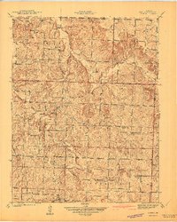 1941 Arnica1941 Print · USGSRural Cedar and St. Clair counties are mapped here just before the Second World War, showing a landscape defined by small farmsteads and creek valleys. Researchers can trace family history through a high density of rural schools and churches like Harvard Sch, Sheek Cem, and Hickory Grove Ch.2 unique versions available
 - 1942 Map of Elkton, 1982 Print
 1942 Elkton1982 Print · USGSHickory and Polk Counties are captured here during a period of transition as the river valley was reshaped by new infrastructure. Genealogists can trace family roots through the Round Tree Cem, Mission Chapel, and many rural schoolhouses like Elkton Sch.
 - 1944 Map of Humansville
 1944 Humansville1944 Print · USGSNear the intersection of three counties in the mid-1940s, this area centered on a thriving rail and agricultural landscape. Local historians can trace family roots through numerous country schoolhouses like Elm Grove Sch and cemeteries such as Richardson Cem.3 unique versions available
 - 1947 Map of Strafford, 1967 Print
 1947 Strafford1967 Print · USGSMissouri's Ozark plateau comes alive in the mid-forties, showing the rural school districts and crossroads towns of Greene and Dallas counties. Trace family roots at Mission Chapel, find the old roadbed of U. S. 66, or locate Tin Town.
 - 1948 Map of Strafford
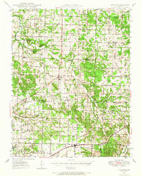
 1948 Strafford1948 Print · USGSMid-century Greene and Webster Counties center on the rail-aligned town of Strafford and the rural crossroads of Fair Grove. Genealogists can locate family landmarks including Mullinx Cem, Hickory Barren Sch, and the old Whitlock Ch.2 unique versions available
 - 1949 Map of Elkton, 1969 Print
 1949 Elkton1969 Print · USGSMid-century Hickory and Polk counties are defined by the winding Pomme De Terre River and a quiet network of rural settlements. Genealogists can trace family footprints through a remarkable density of local schools like Royal Sch and churches including Durnell Chapel.2 unique versions available
 - 1949 Map of Sentinel, 1973 Print
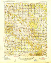
 1949 Sentinel1973 Print · USGSThe Pomme de Terre River valley in Hickory and Polk Counties is shown here just after the war, before modern development altered the rural landscape. Researchers can locate numerous vanished landmarks and family sites like Pittsburg Ch, Stewart Cem, and the Rose Hill Sch.2 unique versions available
End of results
Showing maps 1-7 of 7
Top cities of Polk County
- Bolivar historical maps
- Humansville historical maps
- Pleasant Hope historical maps
- Fair Play historical maps
- Morrisville historical maps
- Halfway historical maps
See more
Frequently asked questions
- What are the different types of historical maps available for Polk County?
- What is the oldest map of Polk County?
- Where can I purchase historical maps of Polk County for my home or office?
- Where can I download high-res historical maps of Polk County?
- Are there historical topographic maps available for Polk County?
- Is there historical aerial imagery available for Polk County?
- Where are historical maps of Polk County sourced from?