1960s Maps of Polk County, Missouri
Explore 5 historic maps of Polk County from the 1960s. These maps offer a rare glimpse into what life looked like during the 1960s — showing old roads, neighborhoods, homes, and landmarks that have changed or disappeared over time.
Whether you're researching your family's past, planning a metal detecting trip, or studying how Polk County's landscape evolved across the 1960s, these high-resolution maps are a powerful tool for exploring the history of this region.
- Focus on a specific era: All maps on this page are from the 1960s, giving you a focused view of this time period.
- See what’s changed: Compare century-old streets, trails, and buildings to today's modern landscape using overlays and satellite layers.
- Research with precision: Use these maps for genealogy, historical research, land use analysis, or educational projects.
- View, download, or print: Maps are fully viewable online in high resolution, and can be downloaded or printed for your own records.
Start exploring Polk County's history through authentic maps from the 1960s. This is your window into the past.
Polk County, MO maps
(5)- 1961 Map of Pleasant Hope, 1962 Print
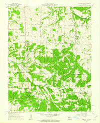 1961 Pleasant Hope1962 Print · USGSThe Polk and Greene County borderlands in the early sixties reveal a landscape of small rural settlements and river-valley farms. Genealogists and local historians can trace the foundations of these communities through landmarks like Brighton, New Hope Sch, and the Tiller Cem.2 unique versions available
 - 1961 Map of Bolivar, 1962 Print
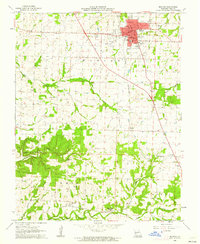 1961 Bolivar1962 Print · USGSBolivar and the surrounding Polk County countryside are captured here in the early sixties as the St Louis San Francisco railroad still linked rural outposts. Genealogists can trace family footprints at Spencer Cem, Hickory Point Ch, or the campus of Southwest Baptist Col.2 unique versions available
 - 1961 Map of Morrisville, 1962 Print
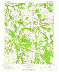 1961 Morrisville1962 Print · USGSThe rural border of Polk and Greene Counties comes into focus in the early sixties, centered on the village of Morrisville and the winding Little Sac River. Researchers can trace the St Louis - San Francisco rail line and locate community landmarks like Oakville Ch and Gays Chapel.2 unique versions available
 - 1961 Map of Half Way, 1962 Print
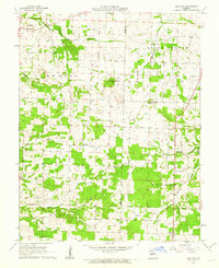 1961 Half Way1962 Print · USGSThe borderlands of Polk and Dallas counties are captured here in the early sixties, showing a landscape of small Missouri farmsteads and creek-side settlements. Genealogists can locate several rural burial grounds and community centers, including Ankrom Cemetery, Garden Cemetery, and Redtop Church.2 unique versions available
 - 1961 Map of Cedar Vista, 1962 Print
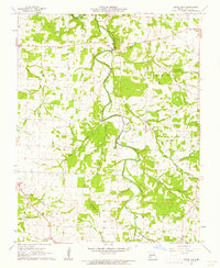 1961 Cedar Vista1962 Print · USGSPolk County, Missouri, is captured here in the early sixties as a network of river-valley farms and crossroad hamlets. Researchers can locate family landmarks like Graveyard Hill, the small settlement of Slagle, and Cem Mt Gilead Ch.
End of results
Showing maps 1-5 of 5
Top cities of Polk County
- Bolivar historical maps
- Humansville historical maps
- Pleasant Hope historical maps
- Fair Play historical maps
- Morrisville historical maps
- Halfway historical maps
See more
Frequently asked questions
- What are the different types of historical maps available for Polk County?
- What is the oldest map of Polk County?
- Where can I purchase historical maps of Polk County for my home or office?
- Where can I download high-res historical maps of Polk County?
- Are there historical topographic maps available for Polk County?
- Is there historical aerial imagery available for Polk County?
- Where are historical maps of Polk County sourced from?