1980s Maps of Dixon, Missouri
Explore 3 historic maps of Dixon from the 1980s. These maps offer a rare glimpse into what life looked like during the 1980s — showing old roads, neighborhoods, homes, and landmarks that have changed or disappeared over time.
Whether you're researching your family's past, planning a metal detecting trip, or studying how Dixon's landscape evolved across the 1980s, these high-resolution maps are a powerful tool for exploring the history of this region.
- Focus on a specific era: All maps on this page are from the 1980s, giving you a focused view of this time period.
- See what’s changed: Compare century-old streets, trails, and buildings to today's modern landscape using overlays and satellite layers.
- Research with precision: Use these maps for genealogy, historical research, land use analysis, or educational projects.
- View, download, or print: Maps are fully viewable online in high resolution, and can be downloaded or printed for your own records.
Start exploring Dixon's history through authentic maps from the 1980s. This is your window into the past.
Dixon, MO maps
(3)- 1982 Map of Lebanon, 1983 Print
 1982 Lebanon1983 Print · USGSThe Missouri Ozarks are captured in the early eighties as Interstate 44 and the St Louis-San Francisco rail line link growing towns with the Fort Leonard Wood Military Reservation. Genealogists and historians can trace family-named sites like Flatwood Church and old post offices at Sleeper and Nebo.
 - 1983 Map of Lake Of The Ozarks, 1984 Print
 1983 Lake Of The Ozarks1984 Print · USGSThe Lake of the Ozarks region in the early eighties shows a landscape of deep river bends and growing recreation. Genealogists can trace family names and small settlements from Versailles to Meta and locate old mining sites like Tiff Mine.
 - 1987 Map of Big Bend
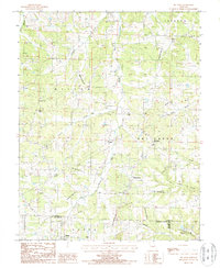 1987 Big Bend1987 Print · USGSThe Maries River valley comes into sharp focus during the late 1980s, showing a landscape shaped by both nature and modern infrastructure. Researchers can trace the rural layout of Big Bend, locate the settlement of Shantytown, and find family sites near Clifty Hollow.
End of results
Showing maps 1-3 of 3
Top cities near Dixon
- Saint Robert historical maps
- Waynesville historical maps
- Crocker historical maps
- Iberia historical maps
- Doolittle historical maps
- Vienna historical maps
See more
Frequently asked questions
- What are the different types of historical maps available for Dixon?
- What is the oldest map of Dixon?
- Where can I purchase historical maps of Dixon for my home or office?
- Where can I download high-res historical maps of Dixon?
- Are there historical topographic maps available for Dixon?
- Is there historical aerial imagery available for Dixon?
- Where are historical maps of Dixon sourced from?