1910s Maps of Lickskillet, Missouri
Explore 2 historic maps of Lickskillet from the 1910s. These maps offer a rare glimpse into what life looked like during the 1910s — showing old roads, neighborhoods, homes, and landmarks that have changed or disappeared over time.
Whether you're researching your family's past, planning a metal detecting trip, or studying how Lickskillet's landscape evolved across the 1910s, these high-resolution maps are a powerful tool for exploring the history of this region.
- Focus on a specific era: All maps on this page are from the 1910s, giving you a focused view of this time period.
- See what’s changed: Compare century-old streets, trails, and buildings to today's modern landscape using overlays and satellite layers.
- Research with precision: Use these maps for genealogy, historical research, land use analysis, or educational projects.
- View, download, or print: Maps are fully viewable online in high resolution, and can be downloaded or printed for your own records.
Start exploring Lickskillet's history through authentic maps from the 1910s. This is your window into the past.
Lickskillet, MO maps
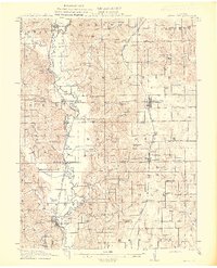
(2)- 1911 Map of Queen City, 1971 Print
 1911 Queen City1971 Print · USGSSchuyler and Adair counties thrive as a rural railway crossroads during the early 1900s. Researchers can locate dozens of country schoolhouses like Patterson School and trace the paths of the Wabash RR through Queen City or the Iowa and St Louis RR near Connelsville.
 - 1913 Map of Queen City
 1913 Queen City1913 Print · USGSSchuyler and Adair counties appear in this pre-war survey as a bustling network of small farming townships and rural school districts. Researchers can trace family roots through dozens of local sites like Queen City, New Hope School, and the river crossing at Slate Ford.2 unique versions available
End of results
Showing maps 1-2 of 2
Top cities near Lickskillet
- Kirksville historical maps
- Lancaster historical maps
- Queen City historical maps
- Novinger historical maps
- Cincinnati historical maps
- Glenwood historical maps
See more
Frequently asked questions
- What are the different types of historical maps available for Lickskillet?
- What is the oldest map of Lickskillet?
- Where can I purchase historical maps of Lickskillet for my home or office?
- Where can I download high-res historical maps of Lickskillet?
- Are there historical topographic maps available for Lickskillet?
- Is there historical aerial imagery available for Lickskillet?
- Where are historical maps of Lickskillet sourced from?