1970s Maps of Worthington, Missouri
Explore 2 historic maps of Worthington from the 1970s. These maps offer a rare glimpse into what life looked like during the 1970s — showing old roads, neighborhoods, homes, and landmarks that have changed or disappeared over time.
Whether you're researching your family's past, planning a metal detecting trip, or studying how Worthington's landscape evolved across the 1970s, these high-resolution maps are a powerful tool for exploring the history of this region.
- Focus on a specific era: All maps on this page are from the 1970s, giving you a focused view of this time period.
- See what’s changed: Compare century-old streets, trails, and buildings to today's modern landscape using overlays and satellite layers.
- Research with precision: Use these maps for genealogy, historical research, land use analysis, or educational projects.
- View, download, or print: Maps are fully viewable online in high resolution, and can be downloaded or printed for your own records.
Start exploring Worthington's history through authentic maps from the 1970s. This is your window into the past.
Worthington, MO maps
(2)- 1974 Map of Queen City NW, 1976 Print
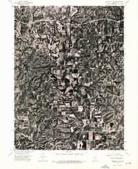 1974 Queen City NW1976 Print · USGSSchuyler County farmland is captured in remarkable aerial detail during the mid-seventies, showing the rural landscape just north of Queen City. Genealogists and local historians can pinpoint farmsteads near Livonia and trace the winding course of the Chariton River past Worthington.
 - 1979 Map of Livonia
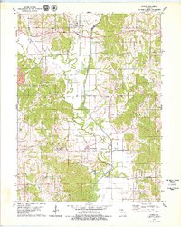 1979 Livonia1979 Print · USGSNortheastern Missouri farmland and river bottoms are captured here in the late seventies as the rural landscape transitioned between old rail eras and modern agriculture. Researchers can trace the Old RR Grade near Worthington or locate numerous historic burial sites like Jimtown Cem and Gillespie Cem.
End of results
Showing maps 1-2 of 2
Top cities near Worthington
- Kirksville historical maps
- Lancaster historical maps
- Queen City historical maps
- Novinger historical maps
- Cincinnati historical maps
- Glenwood historical maps
See more
Frequently asked questions
- What are the different types of historical maps available for Worthington?
- What is the oldest map of Worthington?
- Where can I purchase historical maps of Worthington for my home or office?
- Where can I download high-res historical maps of Worthington?
- Are there historical topographic maps available for Worthington?
- Is there historical aerial imagery available for Worthington?
- Where are historical maps of Worthington sourced from?