1940s Maps of Reynolds County, Missouri
Explore 12 historic maps of Reynolds County from the 1940s. These maps offer a rare glimpse into what life looked like during the 1940s — showing old roads, neighborhoods, homes, and landmarks that have changed or disappeared over time.
Whether you're researching your family's past, planning a metal detecting trip, or studying how Reynolds County's landscape evolved across the 1940s, these high-resolution maps are a powerful tool for exploring the history of this region.
- Focus on a specific era: All maps on this page are from the 1940s, giving you a focused view of this time period.
- See what’s changed: Compare century-old streets, trails, and buildings to today's modern landscape using overlays and satellite layers.
- Research with precision: Use these maps for genealogy, historical research, land use analysis, or educational projects.
- View, download, or print: Maps are fully viewable online in high resolution, and can be downloaded or printed for your own records.
Start exploring Reynolds County's history through authentic maps from the 1940s. This is your window into the past.
Reynolds County, MO maps
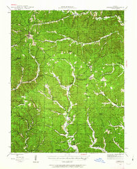
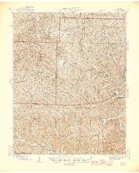
(12)- 1941 Map of Stone Hill, 1958 Print
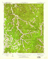 1941 Stone Hill1958 Print · USGSDent County and the Ozark hills are captured here in the early 1940s, just as rural school districts and post-office hamlets still anchored local life. Genealogists and researchers can locate numerous family burial grounds and country schools, including Copeland Cem, Union Ch, and the remote Victory Sch.3 unique versions available
 - 1943 Map of Ellington, 1956 Print
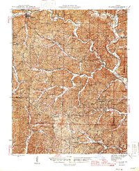
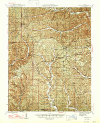
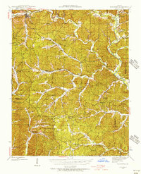 1943 Ellington1956 Print · USGSThe Reynolds County timberlands and river valleys are captured here in the 1940s as the local landscape faced significant change. Genealogists can trace family footprints through numerous rural landmarks like Pine Valley Cem, Garwood, and Carter Mill Sch.
 - 1943 Map of Lesterville, 1957 Print
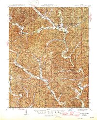
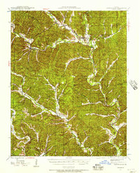 1943 Lesterville1957 Print · USGSThe Black River forks meet in Reynolds County during the 1940s, revealing a landscape of remote hollows and hilltop schools. Genealogists can trace family names at Dobbins Cem and historic school sites like Harrison Valley Sch or Mayberry Sch.2 unique versions available
 - 1943 Map of Boss, 1963 Print
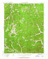 1943 Boss1963 Print · USGSThe Ozark highlands of the early 1940s are revealed here through a network of small family settlements and mountain schools. Genealogists can trace family footprints at Old Mill Lodge, Moses Store, or rural burial sites like Abbott Cem.2 unique versions available
 - 1944 Map of Corridon, 1963 Print
 1944 Corridon1963 Print · USGSThe Missouri Ozarks during the mid-forties reveal a landscape of timbered hollows and isolated settlements across the Reynolds and Shannon County lines. Researchers can trace family sites from Bunker to Fruit City, including Cedar Point Sch and the Latter Day Saints Ch.2 unique versions available
 - 1945 Map of Ellington
 1945 Ellington1945 Print · USGSThe Missouri Ozarks are captured here during the mid-forties, showing the deep-valley settlements of Reynolds and Carter counties. Genealogists can locate family landmarks such as Newton Cem, Doe Run Ch, and the Upper Doe Run Sch.2 unique versions available
 - 1945 Map of Stone Hill
 1945 Stone Hill1945 Print · USGSThe Ozark highlands of Dent County are shown here in the mid-1940s, a landscape defined by the upper Meramec River and deep forest preserves. Researchers can trace rural life through dozens of local landmarks, from the Indian Trail Fish Hatchery to remote settlements like Short Bend and Howes Mill PO.2 unique versions available
 - 1946 Map of Lesterville
 1946 Lesterville1946 Print · USGSReynolds County settlements at the end of the Second World War reveal a landscape of tight-knit valley communities and upland forests. Genealogists can trace family names through landmarks like Shy Cem, Dobbins Mill, and rural schoolhouses such as Skyline Sch.2 unique versions available
 - 1946 Map of Boss
 1946 Boss1946 Print · USGSThe Missouri Ozarks are captured here just after the war, showing the deep hollows and timberlands of the eastern Courtois Hills. Genealogists and researchers can locate family landmarks like Moses Store, the Webb Cem, and numerous rural schoolhouses such as Barton Sch.2 unique versions available
 - 1947 Map of Corridon
 1947 Corridon1947 Print · USGSReynolds and Shannon counties in the late 1940s are shown here as a network of creek-valley settlements and rural schools. Researchers can trace family sites near Bunker, Fruit City, and Dagonia, or locate specific landmarks like Nuckols Cem and Latter Day Saints Ch.
 - 1949 Map of Rolla, 1950 Print
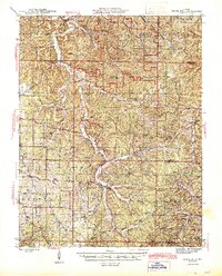
 1949 Rolla1950 Print · USGSThe Missouri Ozarks are captured here just after the war, showing a landscape of deep river valleys and emerging reservoir projects. Genealogists and historians can trace the mining towns of Bonne Terre and Potosi or follow the early route of U.S. Highway 66.
 - 1949 Map of Cardareva, 1957 Print
 1949 Cardareva1957 Print · USGSThe mid-century Ozark backcountry along the Current River is detailed here, showing a landscape of river-bend settlements and deep hollows. Researchers can trace rural life through numerous fords and one-room schoolhouses like Owls Bend School and Cardareva Ford.
End of results
Showing maps 1-12 of 12
Top cities of Reynolds County
Frequently asked questions
- What are the different types of historical maps available for Reynolds County?
- What is the oldest map of Reynolds County?
- Where can I purchase historical maps of Reynolds County for my home or office?
- Where can I download high-res historical maps of Reynolds County?
- Are there historical topographic maps available for Reynolds County?
- Is there historical aerial imagery available for Reynolds County?
- Where are historical maps of Reynolds County sourced from?