1980s Maps of Reynolds County, Missouri
Explore 7 historic maps of Reynolds County from the 1980s. These maps offer a rare glimpse into what life looked like during the 1980s — showing old roads, neighborhoods, homes, and landmarks that have changed or disappeared over time.
Whether you're researching your family's past, planning a metal detecting trip, or studying how Reynolds County's landscape evolved across the 1980s, these high-resolution maps are a powerful tool for exploring the history of this region.
- Focus on a specific era: All maps on this page are from the 1980s, giving you a focused view of this time period.
- See what’s changed: Compare century-old streets, trails, and buildings to today's modern landscape using overlays and satellite layers.
- Research with precision: Use these maps for genealogy, historical research, land use analysis, or educational projects.
- View, download, or print: Maps are fully viewable online in high resolution, and can be downloaded or printed for your own records.
Start exploring Reynolds County's history through authentic maps from the 1980s. This is your window into the past.
Reynolds County, MO maps
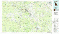
(7)- 1981 Map of Stone Hill, 1982 Print
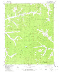 1981 Stone Hill1982 Print · USGSThe Dent County Ozarks come into focus in the early 1980s as the regional timber and mining legacy persists within the national forest. Researchers can trace family roots at Scotia Cem or locate the site of the Scotia Iron Mine and the historic Howes Mill.
 - 1986 Map of Spring Valley
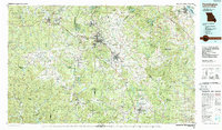
 1986 Spring Valley1986 Print · USGSThe Missouri Ozarks are showcased in the mid-1980s, revealing a landscape defined by state forests and the protected waters of the Current River. Researchers can trace local heritage through landmarks like Oakside Ch, Fletcher Mine, and Summersville Cem.2 unique versions available
 - 1986 Map of Rolla
 1986 Rolla1986 Print · USGSThe Missouri Ozarks are captured here in the mid-1980s, showcasing the intersection of deep forest wilderness and growing highway corridors. Genealogists and local historians can trace family roots through rural landmarks like Salem Memorial Cemetery or the rail-stop history of Cook Station and Steelville.2 unique versions available
 - 1986 Map of Piedmont
 1986 Piedmont1986 Print · USGSThe Missouri Ozarks are captured here in the mid-eighties as a region of dense state forests and critical river management. Genealogists and historians can trace family-named features and rural settlements like Piedmont, Lesterville, and the Yokum School.2 unique versions available
 - 1986 Map of Farmington
 1986 Farmington1986 Print · USGSThe Missouri Lead Belt and the eastern Ozarks are detailed here in the mid-1980s, showcasing a landscape of intensive mining and deep forest. Researchers can trace the Missouri Pacific RR line through industrial centers like Bonne Terre and Flat River, or locate remote landmarks like Elephant Rocks.
 - 1987 Map of Farmington
 1987 Farmington1987 Print · USGSThe St. Francois Mountains and Missouri Lead Belt are shown in the late eighties as industry and conservation converged. Researchers can trace the rail lines of the Missouri Pacific and locate historic mining sites like Mine La Motte and the Iron Mountain Mine.
 - 1989 Map of Rolla
 1989 Rolla1989 Print · USGSThe Missouri Ozarks are captured in the late eighties as a landscape of national forests and historic mining towns. Researchers can trace the rail lines of the Missouri Pacific RR or locate landmarks like Taum Sauk Mtn and Elephant Rocks State Park.
End of results
Showing maps 1-7 of 7
Top cities of Reynolds County
Frequently asked questions
- What are the different types of historical maps available for Reynolds County?
- What is the oldest map of Reynolds County?
- Where can I purchase historical maps of Reynolds County for my home or office?
- Where can I download high-res historical maps of Reynolds County?
- Are there historical topographic maps available for Reynolds County?
- Is there historical aerial imagery available for Reynolds County?
- Where are historical maps of Reynolds County sourced from?