1990s Maps of Munger, Missouri
Explore 1 historic maps of Munger from the 1990s. These maps offer a rare glimpse into what life looked like during the 1990s — showing old roads, neighborhoods, homes, and landmarks that have changed or disappeared over time.
Whether you're researching your family's past, planning a metal detecting trip, or studying how Munger's landscape evolved across the 1990s, these high-resolution maps are a powerful tool for exploring the history of this region.
- Focus on a specific era: All maps on this page are from the 1990s, giving you a focused view of this time period.
- See what’s changed: Compare century-old streets, trails, and buildings to today's modern landscape using overlays and satellite layers.
- Research with precision: Use these maps for genealogy, historical research, land use analysis, or educational projects.
- View, download, or print: Maps are fully viewable online in high resolution, and can be downloaded or printed for your own records.
Start exploring Munger's history through authentic maps from the 1990s. This is your window into the past.
Munger, MO maps
(1)- 1999 Map of Johnson Shut-Ins, 2002 Print
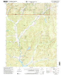 1999 Johnson Shut-Ins2002 Print · USGSThe St. Francois Mountains in the late nineties are shown here at the intersection of public conservation and industrial energy. Researchers can trace rural roots at Marys Chapel or Hasty Cem, alongside the massive Upper Reservoir and power facilities.
End of results
Showing maps 1-1 of 1
Top cities near Munger
- Bismarck historical maps
- Ironton historical maps
- Iron Mountain Lake historical maps
- Pilot Knob historical maps
- Arcadia historical maps
- Centerville historical maps
See more
Frequently asked questions
- What are the different types of historical maps available for Munger?
- What is the oldest map of Munger?
- Where can I purchase historical maps of Munger for my home or office?
- Where can I download high-res historical maps of Munger?
- Are there historical topographic maps available for Munger?
- Is there historical aerial imagery available for Munger?
- Where are historical maps of Munger sourced from?