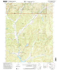
1999 Map of Johnson Shut-Ins
USGS Topo · Published 2002About this map
Johnson Shut-Ins State Park and the surrounding Ozark landscape are defined by the dramatic engineering and geology of the St. Francois Mountains at the end of the twentieth century. The map centers on the East Fork Black River, which flows through the iconic Johnson Shut-Ins before reaching the massive Lower Reservoir. This area is a site of significant energy production, featuring the Taum Sauk Pumped-Storage Hydroelectric Powerplant and the Upper Reservoir perched atop Proffit Mountain.
Find a feature on this map
39 named features on this map. Tap any name to fly to it.
Don’t see what you’re looking for? This feature index may not catch every label — zoom into the map to look around manually.
Map Details
Editions of this 1999 Johnson Shut-Ins Map
This is the sole edition of this map. No revisions or reprints were ever made.
Other maps of this area

1924 · Edgehill
USGS Topo · 1:62,500

1926 · Edgehill
USGS Topo · 1:62,500

1926 · Des Arc
USGS Topo · 1:62,500

1929 · Des Arc
USGS Topo · 1:62,500

1937 · Ironton
USGS Topo · 1:48,000

1943 · Lesterville
USGS Topo · 1:62,500

1945 · Ironton
USGS Topo · 1:62,500

1946 · Lesterville
USGS Topo · 1:62,500

1946 · Ironton
USGS Topo · 1:62,500

1949 · Rolla
USGS Topo · 1:250,000