1970s Maps of Femme Osage, Missouri
Explore 1 historic maps of Femme Osage from the 1970s. These maps offer a rare glimpse into what life looked like during the 1970s — showing old roads, neighborhoods, homes, and landmarks that have changed or disappeared over time.
Whether you're researching your family's past, planning a metal detecting trip, or studying how Femme Osage's landscape evolved across the 1970s, these high-resolution maps are a powerful tool for exploring the history of this region.
- Focus on a specific era: All maps on this page are from the 1970s, giving you a focused view of this time period.
- See what’s changed: Compare century-old streets, trails, and buildings to today's modern landscape using overlays and satellite layers.
- Research with precision: Use these maps for genealogy, historical research, land use analysis, or educational projects.
- View, download, or print: Maps are fully viewable online in high resolution, and can be downloaded or printed for your own records.
Start exploring Femme Osage's history through authentic maps from the 1970s. This is your window into the past.
Femme Osage, MO maps
(1)- 1972 Map of New Melle, 1973 Print
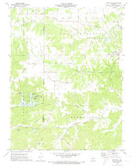 1972 New Melle1973 Print · USGSThe rolling creek valleys of St. Charles and Warren counties are shown here just as new recreational lakes began to dot the landscape. Researchers can trace historic local sites like Emmaus Sanitarium, Friedens Cem, and the old crossroads at Cappeln.2 unique versions available
End of results
Showing maps 1-1 of 1
Top cities near Femme Osage
- O'Fallon historical maps
- Wentzville historical maps
- Wildwood historical maps
- Washington historical maps
- Union historical maps
- Warrenton historical maps
See more
Frequently asked questions
- What are the different types of historical maps available for Femme Osage?
- What is the oldest map of Femme Osage?
- Where can I purchase historical maps of Femme Osage for my home or office?
- Where can I download high-res historical maps of Femme Osage?
- Are there historical topographic maps available for Femme Osage?
- Is there historical aerial imagery available for Femme Osage?
- Where are historical maps of Femme Osage sourced from?