1970s Maps of O'Fallon, Missouri
Explore 4 historic maps of O'Fallon from the 1970s. These maps offer a rare glimpse into what life looked like during the 1970s — showing old roads, neighborhoods, homes, and landmarks that have changed or disappeared over time.
Whether you're researching your family's past, planning a metal detecting trip, or studying how O'Fallon's landscape evolved across the 1970s, these high-resolution maps are a powerful tool for exploring the history of this region.
- Focus on a specific era: All maps on this page are from the 1970s, giving you a focused view of this time period.
- See what’s changed: Compare century-old streets, trails, and buildings to today's modern landscape using overlays and satellite layers.
- Research with precision: Use these maps for genealogy, historical research, land use analysis, or educational projects.
- View, download, or print: Maps are fully viewable online in high resolution, and can be downloaded or printed for your own records.
Start exploring O'Fallon's history through authentic maps from the 1970s. This is your window into the past.
O'Fallon, MO maps
(4)- 1972 Map of Defiance, 1973 Print
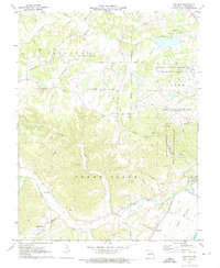 1972 Defiance1973 Print · USGSSt. Charles County in the early seventies shows a landscape balancing historic river settlements and massive post-war conservation and utility tracts. Genealogists and researchers can trace local roots at the Daniel Boone Home, Schluersburg, and the Journey Cem.3 unique versions available
 - 1972 Map of Wentzville, 1973 Print
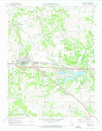 1972 Wentzville1973 Print · USGSWentzville and its surrounding St. Charles County townships are captured here during a period of suburban growth in the early seventies. Genealogists and local historians can trace family-named routes and old communities like Flint Hill, Gilmore, and the historic Weldon Spring Ch.2 unique versions available
 - 1979 Map of Wentzville, 1980 Print
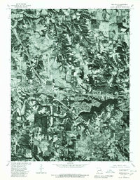 1979 Wentzville1980 Print · USGSSt. Charles County undergoes a visible transformation in the late seventies as residential growth meets rural Missouri farmland. Trace the development of Lake St Louis and examine the early footprints of Wentzville, Josephville, and Gilmore.
 - 1979 Map of Weldon Spring, 1981 Print
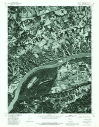 1979 Weldon Spring1981 Print · USGSSt. Charles County in the late seventies is seen here from above, showing the area as a landscape of rural fields and new infrastructure. Trace the early layout of Weldon Spring and Cottleville along the banks of the Missouri River.
End of results
Showing maps 1-4 of 4
Top cities near O'Fallon
- Saint Charles historical maps
- Saint Peters historical maps
- Chesterfield historical maps
- Wentzville historical maps
- Wildwood historical maps
- Ballwin historical maps
See more
Frequently asked questions
- What are the different types of historical maps available for O'Fallon?
- What is the oldest map of O'Fallon?
- Where can I purchase historical maps of O'Fallon for my home or office?
- Where can I download high-res historical maps of O'Fallon?
- Are there historical topographic maps available for O'Fallon?
- Is there historical aerial imagery available for O'Fallon?
- Where are historical maps of O'Fallon sourced from?