1900s (20th Century) Maps of Queen City, Missouri
Explore 8 historic maps of Queen City from the 1900s (20th Century). These maps offer a rare glimpse into what life looked like during the 1900s — showing old roads, neighborhoods, homes, and landmarks that have changed or disappeared over time.
Whether you're researching your family's past, planning a metal detecting trip, or studying how Queen City's landscape evolved across the 1900s, these high-resolution maps are a powerful tool for exploring the history of this region.
- Focus on a specific era: All maps on this page are from the 1900s, giving you a focused view of this time period.
- See what’s changed: Compare century-old streets, trails, and buildings to today's modern landscape using overlays and satellite layers.
- Research with precision: Use these maps for genealogy, historical research, land use analysis, or educational projects.
- View, download, or print: Maps are fully viewable online in high resolution, and can be downloaded or printed for your own records.
Start exploring Queen City's history through authentic maps from the 1900s. This is your window into the past.
Queen City, MO maps
(8)- 1911 Map of Queen City, 1971 Print
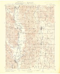
 1911 Queen City1971 Print · USGSSchuyler and Adair counties thrive as a rural railway crossroads during the early 1900s. Researchers can locate dozens of country schoolhouses like Patterson School and trace the paths of the Wabash RR through Queen City or the Iowa and St Louis RR near Connelsville.
 - 1913 Map of Queen City
 1913 Queen City1913 Print · USGSSchuyler and Adair counties appear in this pre-war survey as a bustling network of small farming townships and rural school districts. Researchers can trace family roots through dozens of local sites like Queen City, New Hope School, and the river crossing at Slate Ford.2 unique versions available
 - 1954 Map of Centerville, 1967 Print
 1954 Centerville1967 Print · USGSThe Iowa-Missouri borderlands at mid-century reveal a landscape shaped by river valleys and the height of the regional rail network. Genealogists and historians can trace the paths of the Wabash railroad and locate old townsites like Mystic, Moulton, and Greentop.3 unique versions available
 - 1957 Map of Centerville
 1957 Centerville1957 Print · USGSThe Iowa-Missouri borderlands in the mid-fifties reveal a landscape of river-valley agriculture and vital rail corridors. Genealogists and historians can trace family-named landmarks and small-town growth in Centerville, Kirksville, and along the Wabash railroad line.
 - 1958 Map of Centerville
 1958 Centerville1958 Print · USGSThe Iowa-Missouri borderlands come into focus during the mid-fifties, showing a landscape defined by river valleys and intersecting rail lines. Genealogists and local historians can trace family roots through dozens of rural hubs like Bloomfield, Unionville, and Corydon.
 - 1974 Map of Queen City NE, 1976 Print
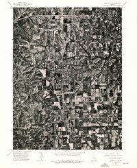 1974 Queen City NE1976 Print · USGSSchuyler County's agricultural landscape is captured with photographic precision during the mid-seventies. Researchers can trace the development of the local road network and examine the physical footprint of Queen City and its surrounding farmsteads.
 - 1979 Map of Queen City
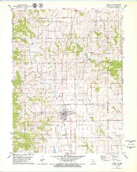 1979 Queen City1979 Print · USGSSchuyler County at the end of the 1970s shows a landscape defined by the Norfolk and Western rail corridor and rural community life. Genealogists can trace family names at the New Hope Ch Graves, Tarr Cem, and Myers Cem.
 - 1981 Map of Kirksville, 1982 Print
 1981 Kirksville1982 Print · USGSNortheast Missouri in the early eighties was a landscape of rail-connected trade towns and significant river valleys. Researchers can trace the legacy of medical education at the Kirksville College of Osteopathic Med or locate family roots in Unionville, Edina, and Bible Grove.
End of results
Showing maps 1-8 of 8
Top cities near Queen City
- Kirksville historical maps
- Lancaster historical maps
- Novinger historical maps
- Downing historical maps
- Glenwood historical maps
- Livonia historical maps
See more
Frequently asked questions
- What are the different types of historical maps available for Queen City?
- What is the oldest map of Queen City?
- Where can I purchase historical maps of Queen City for my home or office?
- Where can I download high-res historical maps of Queen City?
- Are there historical topographic maps available for Queen City?
- Is there historical aerial imagery available for Queen City?
- Where are historical maps of Queen City sourced from?