1940s Maps of Terry, Missouri
Explore 2 historic maps of Terry from the 1940s. These maps offer a rare glimpse into what life looked like during the 1940s — showing old roads, neighborhoods, homes, and landmarks that have changed or disappeared over time.
Whether you're researching your family's past, planning a metal detecting trip, or studying how Terry's landscape evolved across the 1940s, these high-resolution maps are a powerful tool for exploring the history of this region.
- Focus on a specific era: All maps on this page are from the 1940s, giving you a focused view of this time period.
- See what’s changed: Compare century-old streets, trails, and buildings to today's modern landscape using overlays and satellite layers.
- Research with precision: Use these maps for genealogy, historical research, land use analysis, or educational projects.
- View, download, or print: Maps are fully viewable online in high resolution, and can be downloaded or printed for your own records.
Start exploring Terry's history through authentic maps from the 1940s. This is your window into the past.
Terry, MO maps
(2)- 1940 Map of Weaubleau, 1954 Print
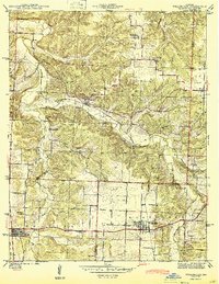
 1940 Weaubleau1954 Print · USGSThe St. Clair and Hickory county line area comes into focus in the 1940s, showing a landscape of rail-linked towns and local school districts. Trace family roots at Robinson Cem or explore the old routes through Gerster, Collins, and Weaubleau.2 unique versions available
 - 1944 Map of Weaubleau
 1944 Weaubleau1944 Print · USGSHickory and St. Clair Counties come into focus during the early 1940s as the railroad and rural school districts defined local life. Researchers can trace family-named landmarks and early homesteads near Weaubleau, Gerster, and Robinson Cem.2 unique versions available
End of results
Showing maps 1-2 of 2
Top cities near Terry
- Humansville historical maps
- Osceola historical maps
- Lowry City historical maps
- Weaubleau historical maps
- Hermitage historical maps
- Wheatland historical maps
See more
Frequently asked questions
- What are the different types of historical maps available for Terry?
- What is the oldest map of Terry?
- Where can I purchase historical maps of Terry for my home or office?
- Where can I download high-res historical maps of Terry?
- Are there historical topographic maps available for Terry?
- Is there historical aerial imagery available for Terry?
- Where are historical maps of Terry sourced from?