
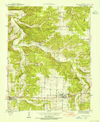
1940 Map of Weaubleau
USGS Topo · Published 1954About this map
Weaubleau serves as a primary hub for this southwestern Missouri landscape, situated near the border of St Clair and Hickory counties. The area is defined by a dense network of rural school districts, including Oak Grove, Kings Prairie, Burgess, and Climax, reflecting the era's localized educational structure before mid-century consolidation. The St Louis San Francisco railroad cuts through the center of the sheet, connecting the town of Gerster to the surrounding settlements. To the south, the village of Collins sits near the headwaters of Coon Creek. Natural landmarks like Boswell Bluff overlook the winding course of Weaubleau Creek, while the Robinson Cem provides a specific point of interest for genealogists researching families from the Weaubleau or Collins townships during this period.
Find a feature on this map
31 named features on this map. Tap any name to fly to it.
Don’t see what you’re looking for? This feature index may not catch every label — zoom into the map to look around manually.
Map Details
Editions of this 1940 Weaubleau Map
2 editions found
Other maps of this area

1884 · Bolivar
USGS Topo · 1:125,000

1886 · Stockton
USGS Topo · 1:125,000

1887 · Clinton
USGS Topo · 1:125,000

1887 · Warsaw
USGS Topo · 1:125,000

1892 · Bolivar
USGS Topo · 1:125,000

1894 · Warsaw
USGS Topo · 1:125,000

1894 · Clinton
USGS Topo · 1:125,000

1938 · Vista
USGS Topo · 1:24,000

1939 · Osceola
USGS Topo · 1:24,000

1939 · Arnica
USGS Topo · 1:24,000