Old Maps of Terry, Missouri for Hiking & Exploration
Hike through history with 12 historic maps of Terry. Explore old trails, ghost towns, and forgotten backroads — perfect for outdoor adventurers and local explorers.
- Rediscover forgotten places: Map out old mining camps, roads, and footpaths that no longer exist on modern maps.
- Layer with modern tools: Combine with LiDAR or satellite views to plan hikes through historical terrain.
- Made for exploration: Popular among hikers, overlanders, and local history lovers.
Use these maps to find adventure and explore the hidden past of Terry.
Terry, MO maps
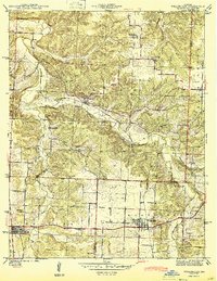
(12)- 1886 Map of Stockton
 1886 Stockton1886 Print · USGSSouthwest Missouri in the mid-1880s was a landscape of river-bottom farms and emerging rail towns along the Kansas City Clinton and Springfield R. R. Trace vanished post offices and local landmarks like Johnson's Mill, Dunnegan Springs, and the early streets of Stockton.3 unique versions available
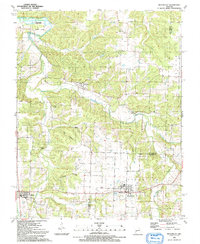
 - 1940 Map of Weaubleau, 1954 Print
 1940 Weaubleau1954 Print · USGSThe St. Clair and Hickory county line area comes into focus in the 1940s, showing a landscape of rail-linked towns and local school districts. Trace family roots at Robinson Cem or explore the old routes through Gerster, Collins, and Weaubleau.2 unique versions available
 - 1944 Map of Weaubleau
 1944 Weaubleau1944 Print · USGSHickory and St. Clair Counties come into focus during the early 1940s as the railroad and rural school districts defined local life. Researchers can trace family-named landmarks and early homesteads near Weaubleau, Gerster, and Robinson Cem.2 unique versions available
 - 1954 Map of Springfield
 1954 Springfield1954 Print · USGSThe Missouri Ozarks are captured here during the post-war era, showing the expansion of Springfield and the surrounding river valleys. Genealogists and historians can trace local landmarks like Mount Comfort Cemetery and the Fort Leonard Wood military grounds.6 unique versions available
 - 1958 Map of Springfield
 1958 Springfield1958 Print · USGSThe Missouri Ozarks are captured during the mid-century era of growth, centered on the bustling hub of Springfield. Genealogists and historians can trace family roots through numerous landmarks like Ebenezer Church, Stockton Cem, and the various county courthouses.
 - 1959 Map of Springfield
 1959 Springfield1959 Print · USGSThe Missouri Ozarks are captured here during a decade of postwar growth and increasing highway connectivity. Researchers can trace the legacy of the St Louis-San Francisco RR and locate early sites in Springfield, Lebanon, and Mountain Grove.
 - 1984 Map of Bolivar
 1984 Bolivar1984 Print · USGSWestern Missouri in the mid-eighties shows a landscape shaped by large-scale water management and rail commerce. Genealogists and historians can trace the development of towns like Bolivar and El Dorado Springs alongside the massive Stockton Lake.
 - 1991 Map of Weaubleau
 1991 Weaubleau1991 Print · USGSLife along the Hickory and St. Clair county line in the early nineties centered on small agricultural hubs and creek valleys. Genealogists and historians can trace the Old Railroad Grade past Gerster or locate the Robinson Cem and Kings Prairie Ch.
 - 2011 Map of Weaubleau, 2011 Print
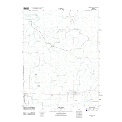 2011 Weaubleau2011 Print · USGSCovers Terry, including Weaubleau, Collins, and other nearby areas
 - 2015 Map of Weaubleau, 2015 Print
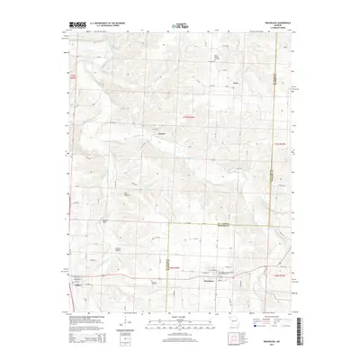 2015 Weaubleau2015 Print · USGSCovers Terry, including Weaubleau, Collins, and other nearby areas
 - 2017 Map of Weaubleau, 2017 Print
 2017 Weaubleau2017 Print · USGSCovers Terry, including Weaubleau, Collins, and other nearby areas
 - 2021 Map of Weaubleau, 2021 Print
 2021 Weaubleau2021 Print · USGSThe borderlands of St. Clair and Hickory counties come into focus in the early 2020s, centered on the historic crossroads of Weaubleau. Researchers can trace local heritage through landmarks like the Weaubleau Congregational Christian Cem and the rural reaches of Possum Hollow.
End of results
Showing maps 1-12 of 12
Top cities near Terry
- Humansville historical maps
- Osceola historical maps
- Lowry City historical maps
- Weaubleau historical maps
- Hermitage historical maps
- Wheatland historical maps
See more
Frequently asked questions
- What are the different types of historical maps available for Terry?
- What is the oldest map of Terry?
- Where can I purchase historical maps of Terry for my home or office?
- Where can I download high-res historical maps of Terry?
- Are there historical topographic maps available for Terry?
- Is there historical aerial imagery available for Terry?
- Where are historical maps of Terry sourced from?