1980s Maps of Ste. Genevieve County, Missouri
Explore 11 historic maps of Ste. Genevieve County from the 1980s. These maps offer a rare glimpse into what life looked like during the 1980s — showing old roads, neighborhoods, homes, and landmarks that have changed or disappeared over time.
Whether you're researching your family's past, planning a metal detecting trip, or studying how Ste. Genevieve County's landscape evolved across the 1980s, these high-resolution maps are a powerful tool for exploring the history of this region.
- Focus on a specific era: All maps on this page are from the 1980s, giving you a focused view of this time period.
- See what’s changed: Compare century-old streets, trails, and buildings to today's modern landscape using overlays and satellite layers.
- Research with precision: Use these maps for genealogy, historical research, land use analysis, or educational projects.
- View, download, or print: Maps are fully viewable online in high resolution, and can be downloaded or printed for your own records.
Start exploring Ste. Genevieve County's history through authentic maps from the 1980s. This is your window into the past.
Ste. Genevieve County, MO maps
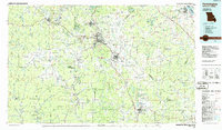
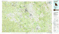
(11)- 1980 Map of Weingarten
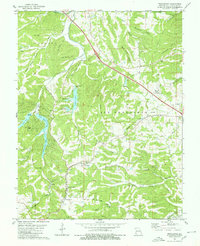 1980 Weingarten1980 Print · USGSSte. Genevieve County in the late 1970s reveals a rural landscape shaped by Catholic heritage and a legacy of mineral extraction. Researchers can trace the Missouri Pacific rail line as it passes New Offenburg, locate the historic Copper Mines, and find family sites near Our Lady of Help Sch.
 - 1980 Map of Minnith
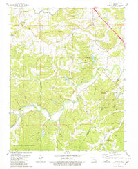 1980 Minnith1980 Print · USGSThe borderlands of Ste. Genevieve and Perry counties are captured here in the late twentieth century, showing a landscape of timbered ridges and family farms. Local historians can trace family burial sites like Roth Cem and Hand Cem or locate old landmarks such as Minnehaha Lake and Ozora.
 - 1980 Map of Knob Lick
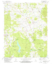 1980 Knob Lick1980 Print · USGSIn the 1970s and 80s, these rural Missouri uplands were a mix of small crossroads settlements and family farms along the county lines. Researchers can trace local lineage through Wesley Chapel Cemetery and Sebastian Cemetery, or locate landmarks like Castle Rock and the S-F Scout Ranch.2 unique versions available
 - 1980 Map of Coffman
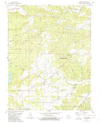 1980 Coffman1980 Print · USGSSte. Genevieve County is captured here in the late seventies, a landscape where public forest land meets established rural settlements. Genealogists can trace family roots at Stone Church Cemetery, Jackson Cemetery, and the old Coffman School.
 - 1984 Map of Carbondale, 1985 Print
 1984 Carbondale1985 Print · USGSSouthern Illinois in the mid-1980s was a crossroads of major rail lines and vast conservation lands centered on Carbondale. Local researchers can trace the development of Southern Illinois University, the Menard Correctional Center, and the many shorelines of Crab Orchard Lake.
 - 1985 Map of Festus, 1987 Print
 1985 Festus1987 Print · USGSThe Mississippi River corridor and Ozark foothills appear here in the mid-1980s, documenting a landscape of industrial river towns and forest preserves. Trace the development of Festus, Crystal City, and De Soto or locate sites like Mastodon State Park.
 - 1986 Map of Carbondale
 1986 Carbondale1986 Print · USGSSouthern Illinois and the Mississippi River valley are captured in the mid-eighties as a landscape of diverse water systems and conservation lands. Researchers can trace the development of Southern Illinois University or locate landmarks like Fort Gage and St Marys Seminary.
 - 1986 Map of Farmington
 1986 Farmington1986 Print · USGSThe Missouri Lead Belt and the eastern Ozarks are detailed here in the mid-1980s, showcasing a landscape of intensive mining and deep forest. Researchers can trace the Missouri Pacific RR line through industrial centers like Bonne Terre and Flat River, or locate remote landmarks like Elephant Rocks.
 - 1987 Map of Farmington
 1987 Farmington1987 Print · USGSThe St. Francois Mountains and Missouri Lead Belt are shown in the late eighties as industry and conservation converged. Researchers can trace the rail lines of the Missouri Pacific and locate historic mining sites like Mine La Motte and the Iron Mountain Mine.
 - 1987 Map of Paducah, 1988 Print
 1987 Paducah1988 Print · USGSThe Lower Ohio Valley and the Illinois Ozarks come alive in this late twentieth-century regional survey. Genealogists and local historians can trace river-town roots and state park landmarks from Metropolis to Cape Girardeau and Trail of Tears State Park.
 - 1989 Map of Rolla
 1989 Rolla1989 Print · USGSThe Missouri Ozarks are captured in the late eighties as a landscape of national forests and historic mining towns. Researchers can trace the rail lines of the Missouri Pacific RR or locate landmarks like Taum Sauk Mtn and Elephant Rocks State Park.
End of results
Showing maps 1-11 of 11
Top cities of Ste. Genevieve County
Frequently asked questions
- What are the different types of historical maps available for Ste. Genevieve County?
- What is the oldest map of Ste. Genevieve County?
- Where can I purchase historical maps of Ste. Genevieve County for my home or office?
- Where can I download high-res historical maps of Ste. Genevieve County?
- Are there historical topographic maps available for Ste. Genevieve County?
- Is there historical aerial imagery available for Ste. Genevieve County?
- Where are historical maps of Ste. Genevieve County sourced from?