1940s Maps of Aquilla, Missouri
Explore 1 historic maps of Aquilla from the 1940s. These maps offer a rare glimpse into what life looked like during the 1940s — showing old roads, neighborhoods, homes, and landmarks that have changed or disappeared over time.
Whether you're researching your family's past, planning a metal detecting trip, or studying how Aquilla's landscape evolved across the 1940s, these high-resolution maps are a powerful tool for exploring the history of this region.
- Focus on a specific era: All maps on this page are from the 1940s, giving you a focused view of this time period.
- See what’s changed: Compare century-old streets, trails, and buildings to today's modern landscape using overlays and satellite layers.
- Research with precision: Use these maps for genealogy, historical research, land use analysis, or educational projects.
- View, download, or print: Maps are fully viewable online in high resolution, and can be downloaded or printed for your own records.
Start exploring Aquilla's history through authentic maps from the 1940s. This is your window into the past.
Aquilla, MO maps
(1)- 1949 Map of Bloomfield, 1958 Print
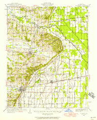 1949 Bloomfield1958 Print · USGSStoddard County is documented here during the post-war years as its agricultural drainage systems and rail networks reached their peak. Local historians can trace family roots through numerous rural landmarks like Dowdy Cem, Holly Ch, and the Walnut Ridge Sch.
End of results
Showing maps 1-1 of 1
Top cities near Aquilla
- Dexter historical maps
- Bloomfield historical maps
- Advance historical maps
- Morehouse historical maps
- Essex historical maps
- Bell City historical maps
See more
Frequently asked questions
- What are the different types of historical maps available for Aquilla?
- What is the oldest map of Aquilla?
- Where can I purchase historical maps of Aquilla for my home or office?
- Where can I download high-res historical maps of Aquilla?
- Are there historical topographic maps available for Aquilla?
- Is there historical aerial imagery available for Aquilla?
- Where are historical maps of Aquilla sourced from?