1950s Maps of Texas County, Missouri
Explore 31 historic maps of Texas County from the 1950s. These maps offer a rare glimpse into what life looked like during the 1950s — showing old roads, neighborhoods, homes, and landmarks that have changed or disappeared over time.
Whether you're researching your family's past, planning a metal detecting trip, or studying how Texas County's landscape evolved across the 1950s, these high-resolution maps are a powerful tool for exploring the history of this region.
- Focus on a specific era: All maps on this page are from the 1950s, giving you a focused view of this time period.
- See what’s changed: Compare century-old streets, trails, and buildings to today's modern landscape using overlays and satellite layers.
- Research with precision: Use these maps for genealogy, historical research, land use analysis, or educational projects.
- View, download, or print: Maps are fully viewable online in high resolution, and can be downloaded or printed for your own records.
Start exploring Texas County's history through authentic maps from the 1950s. This is your window into the past.
Texas County, MO maps
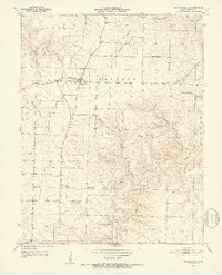
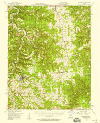
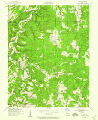
(31)- 1950 Map of Cabool SW, 1952 Print
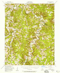
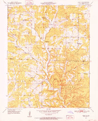 1950 Cabool SW1952 Print · USGSTexas and Douglas Counties in the early 1950s show a rugged Ozark landscape of national forest and family farms. Trace local history through numerous rural landmarks like Macedonia Cem, Onyx Cave, and several schools including Pine Flat Sch and Little Creek Sch.3 unique versions available
 - 1951 Map of Montauk, 1952 Print
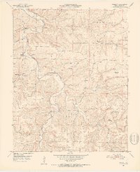
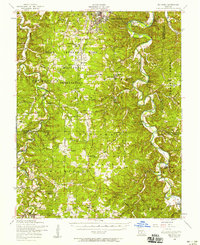
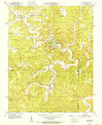 1951 Montauk1952 Print · USGSThe headwaters of the Current River are captured here in the early fifties, showing the development of Montauk State Park. Researchers can trace old family sites and rural institutions like Paterson Cem, Hepsida Ch, and Alred Sch.5 unique versions available
 - 1951 Map of Mountain Grove South, 1952 Print
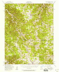
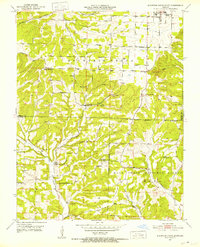 1951 Mountain Grove South1952 Print · USGSThe Missouri Ozarks south of Mountain Grove are shown here in the early 1950s as a landscape of rural schools and winding creek valleys. Researchers can locate family landmarks like Strunk Cem and old country schools including Oak Grove Sch and Fairmount Sch.3 unique versions available
 - 1951 Map of Licking, 1952 Print
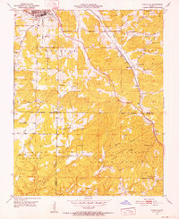
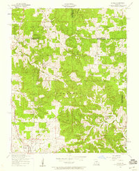
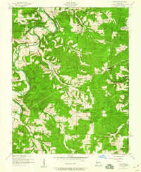
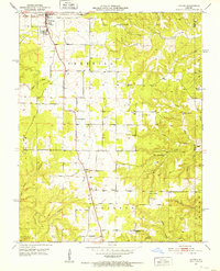 1951 Licking1952 Print · USGSMid-century Texas County Missouri comes alive in this survey, showing the rural landscape around Licking just after the war. Local historians can trace family ties at sites like Shipp Cem, Mahan Cem, and the old Wildwood Sch.3 unique versions available
 - 1951 Map of Raymondville, 1952 Print
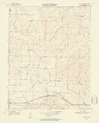
 1951 Raymondville1952 Print · USGSTexas County communities and rural school districts are captured here in the early fifties. Genealogists and local historians can trace the foundations of Raymondville, find the Allen Cem, and locate old sites like High Point Sch.3 unique versions available
 - 1951 Map of Prescott, 1952 Print
 1951 Prescott1952 Print · USGSTexas County in the early fifties reveals a landscape of tight-knit rural communities along the Big Piney River. Genealogists can locate family landmarks like Sliger Cem, Venable Sch, and the riverside crossing at Sandy Shoals Ford.5 unique versions available
 - 1951 Map of Cabool SE, 1952 Print
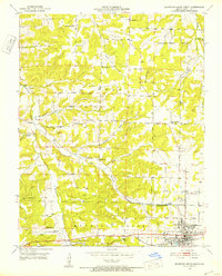
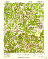
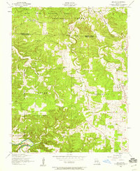
 1951 Cabool SE1952 Print · USGSTexas and Howell counties in the early 1950s reveal a landscape divided between the busy rail town of Cabool and the deep woods of the Ozarks. Genealogists can trace rural life through sites like Pea Ridge Ch, the Jones Cem, and the now-abandoned Forest Flower Sch.6 unique versions available
 - 1951 Map of Houston, 1952 Print
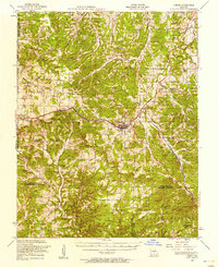
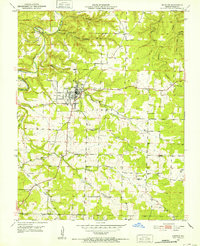 1951 Houston1952 Print · USGSHouston and the surrounding Ozark hills are captured in the early 1950s, showing a landscape defined by deep hollows and creek-side settlements. Researchers can trace family roots at Duke Cem or locate rural landmarks like Brown Hill Sch and Central Ch.4 unique versions available
 - 1951 Map of Mountain Grove North, 1952 Print
 1951 Mountain Grove North1952 Print · USGSWright County life in the early fifties centered around the rail-connected hub of Mountain Grove and its surrounding hill country. Researchers can trace rural community roots through numerous local sites like Morning Sun Church, Fairview School, and Hillcrest Cemetery.2 unique versions available
 - 1951 Map of Cabool NW, 1952 Print
 1951 Cabool NW1952 Print · USGSTexas and Wright Counties are captured here in the early fifties, showing a rural landscape of dispersed hill farms and tight-knit school districts. Genealogists can locate family landmarks like Stubbs Cem, the Dunn (Impo PO) settlement, and the old Gravel Point Sch.3 unique versions available
 - 1951 Map of Cabool NE, 1952 Print
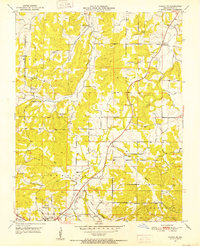 1951 Cabool NE1952 Print · USGSTexas County was a landscape of small communities and rural schoolhouses during the early fifties, situated around the Big Piney River. You can trace ancestral roots at Hamilton Creek Cemetery or locate the old Simmons School and Providence Church.4 unique versions available
 - 1951 Map of Hartshorn, 1952 Print
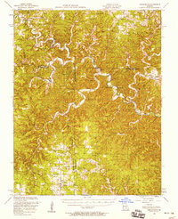
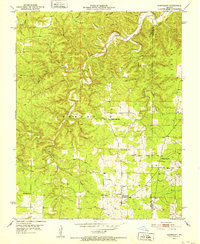 1951 Hartshorn1952 Print · USGSThe Ozark highlands near Hartshorn are captured here in the early fifties, showing a landscape defined by the winding Current River. Local historians can locate vanished landmarks like Round Valley Sch and family-named sites such as Smith Cem or Center Valley Ch.4 unique versions available
 - 1951 Map of Cabool, 1958 Print
 1951 Cabool1958 Print · USGSThe Ozark Plateau near Cabool and Mountain Grove is shown here in the early fifties, centering on the St Louis-San Francisco RR corridor. Genealogists can trace family landmarks like Cedar Bluff Cem, Hamilton Creek Church, and several rural schools.2 unique versions available
 - 1951 Map of Mountain Grove, 1958 Print
 1951 Mountain Grove1958 Print · USGSWright and Douglas counties come alive in the early fifties, showing a landscape of small farmsteads and rural schoolhouses. Genealogists can locate specific family landmarks like Day Cem, Owens, and the St Louis San Francisco RR corridor.
 - 1951 Map of Raymondville, 1958 Print
 1951 Raymondville1958 Print · USGSTexas County, Missouri, is shown here in the early fifties, capturing a landscape of small upland farms and Ozark river bends. Genealogists and local historians can locate dozens of country schools and churches, such as the Whitlock School, Boone Creek Church, and the County Farm Cemetery.3 unique versions available
 - 1951 Map of Cedargrove, 1958 Print
 1951 Cedargrove1958 Print · USGSThe Current River valley and the rural hills of Shannon and Texas counties come alive in the early fifties. Genealogists and historians can trace family roots through numerous country landmarks like Jadwin School, Antioch Cem, and Hartshorn Lookout Tower.3 unique versions available
 - 1953 Map of Rolla
 1953 Rolla1953 Print · USGSSoutheast Missouri’s mining towns and timberlands are seen here at the start of the 1950s. Genealogists and historians can trace the rail-and-river economy through local hubs like Fredericktown and the lead-mining heritage of Potosi and Desloge.
 - 1954 Map of Springfield
 1954 Springfield1954 Print · USGSThe Missouri Ozarks are captured here during the post-war era, showing the expansion of Springfield and the surrounding river valleys. Genealogists and historians can trace local landmarks like Mount Comfort Cemetery and the Fort Leonard Wood military grounds.6 unique versions available
 - 1954 Map of Drynob, 1958 Print
 1954 Drynob1958 Print · USGSThe rural hills of Laclede County are captured here in the mid-fifties as many one-room schoolhouses were beginning to close. You can trace early Ozark river crossings at Hall Ford Bridge or locate family sites like the Stewart Cemetery and Mt Pleasant Church.2 unique versions available
 - 1954 Map of Big Piney, 1958 Print
 1954 Big Piney1958 Print · USGSThe mid-century Ozark highlands are captured here during a period of massive federal transition, as military expansion met traditional rural life. Researchers can trace family names and vanished sites through the Bloodland Cemetery, the Roby Lookout Tower, and several abandoned schoolhouses like Morman Valley School.3 unique versions available
 - 1954 Map of Edgar Springs, 1958 Print
 1954 Edgar Springs1958 Print · USGSThe northern Ozarks come alive in this mid-century survey of the Phelps, Dent, and Texas county borders. Trace the location of family landmarks and community centers like the Lady of Perpetual Help Church, West Point School, and Beulah Cemetery.2 unique versions available
 - 1954 Map of Maples, 1959 Print
 1954 Maples1959 Print · USGSThe rural borderlands of Texas and Dent counties are captured here in the mid-1950s. Researchers can trace dozens of family landmarks and local community centers, from Stoney Point School and Bethel Church to the early layout of Licking.2 unique versions available
 - 1954 Map of Roby, 1959 Print
 1954 Roby1959 Print · USGSThe Missouri Ozarks during the mid-1950s reveals a landscape of dense national forest and expanding military grounds. Genealogists can trace family footprints at Macedonia Cemetery or locate the former sites of rural education at Bloodland School and Blackjack School.3 unique versions available
 - 1954 Map of Winnipeg, 1959 Print
 1954 Winnipeg1959 Print · USGSLaclede and Texas Counties are documented here in the mid-1950s, showing the rural communities and forest lands along the Gasconade River. Researchers can locate family landmarks like the Winnipeg Cem and multiple local schools, including several noted as abandoned like the Morehouse School.2 unique versions available
 - 1954 Map of Beulah, 1959 Print
 1954 Beulah1959 Print · USGSThe Ozark woodlands of Texas County were still dotted with one-room schools and family burial grounds in the mid-1950s. Trace the rural landscape through Beulah, find the Licking State Forest Nursery, or locate landmarks like Craddock School and Texas Lookout Tower.2 unique versions available
Showing maps 1-25 of 31
Top cities of Texas County
- Sherrill historical maps
- Cabool historical maps
- Houston historical maps
- Roubidoux historical maps
- Licking historical maps
- Upton historical maps
See more
Frequently asked questions
- What are the different types of historical maps available for Texas County?
- What is the oldest map of Texas County?
- Where can I purchase historical maps of Texas County for my home or office?
- Where can I download high-res historical maps of Texas County?
- Are there historical topographic maps available for Texas County?
- Is there historical aerial imagery available for Texas County?
- Where are historical maps of Texas County sourced from?