1980s Maps of Webster County, Missouri
Explore 11 historic maps of Webster County from the 1980s. These maps offer a rare glimpse into what life looked like during the 1980s — showing old roads, neighborhoods, homes, and landmarks that have changed or disappeared over time.
Whether you're researching your family's past, planning a metal detecting trip, or studying how Webster County's landscape evolved across the 1980s, these high-resolution maps are a powerful tool for exploring the history of this region.
- Focus on a specific era: All maps on this page are from the 1980s, giving you a focused view of this time period.
- See what’s changed: Compare century-old streets, trails, and buildings to today's modern landscape using overlays and satellite layers.
- Research with precision: Use these maps for genealogy, historical research, land use analysis, or educational projects.
- View, download, or print: Maps are fully viewable online in high resolution, and can be downloaded or printed for your own records.
Start exploring Webster County's history through authentic maps from the 1980s. This is your window into the past.
Webster County, MO maps
(11)- 1982 Map of Niangua, 1983 Print
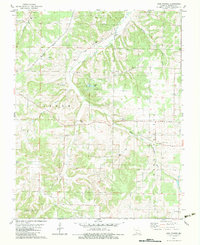
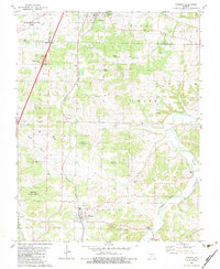 1982 Niangua1983 Print · USGSThis part of Webster and Laclede counties in the early eighties shows a landscape of small Ozark settlements and timbered state lands. Researchers can locate family landmarks like Letterman Cem, the village of Niangua, and rural churches such as Mathis Ch.
 - 1982 Map of Seymour, 1983 Print
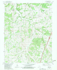
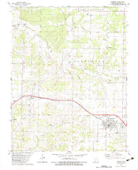 1982 Seymour1983 Print · USGSSeymour and Diggins were thriving rail-side communities in the early eighties as the railroad shaped the development of Webster County. Genealogists can trace family roots through the Civil War Cem, Bright Prairie Sch, and Masonic Cems.
 - 1982 Map of Dogwood, 1983 Print
 1982 Dogwood1983 Print · USGSThe Ozark highlands of the Webster and Douglas county border are captured here in the early eighties. Genealogists can trace family names through numerous rural burial sites like Cardwell Cem and Silvey Cem or locate the community center of Dogwood.
 - 1982 Map of Fordland, 1983 Print
 1982 Fordland1983 Print · USGSFordland and the surrounding Webster County countryside are shown here in the early eighties, centered on the vital Burlington Northern rail corridor. Researchers can trace local history through numerous rural landmarks like Pleasant Grove Ch, the Fordland Honor Camp, and several family cemeteries.
 - 1982 Map of Bruner, 1983 Print
 1982 Bruner1983 Print · USGSOzark hill country at the intersection of Christian, Webster, and Douglas Counties is captured here in the early eighties. Genealogists and local historians can trace small communities like Bruner and Elkhead alongside landmarks such as Swearengin Cem and Honey Branch Caves.
 - 1982 Map of High Prairie, 1983 Print
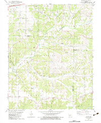
 1982 High Prairie1983 Print · USGSWebster County in the early eighties shows a landscape defined by its river forks and upland prairies. Genealogists can trace family names and rural centers like High Prairie, the Shields-Corinth Cem, and Old Liberty Ch.
 - 1982 Map of Springfield, 1983 Print
 1982 Springfield1983 Print · USGSSpringfield and the surrounding Ozark plateau are captured in the early eighties as the region balanced urban growth with its agricultural roots. Genealogists and researchers can trace the locations of White Chapel, the State Sanatorium, and older rail stops like Brookline.
 - 1982 Map of Beach, 1983 Print
 1982 Beach1983 Print · USGSThe Niangua River valley and its timbered uplands define this Missouri landscape in the early eighties. Local researchers can trace family roots through Thorpe Cem and Marlin Cem or locate old community centers like Beach and Forkners Hill.
 - 1982 Map of Marshfield, 1983 Print
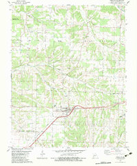
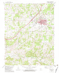 1982 Marshfield1983 Print · USGSMarshfield and the surrounding Ozark hill country are documented here in the early eighties. Genealogists can trace family footprints through numerous rural landmarks like Bumgarner Cem, the Friendship Ch, and the small settlement of Northview.
 - 1983 Map of Mountain Grove
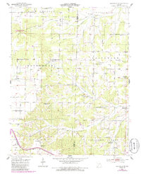
 1983 Mountain Grove1983 Print · USGSWright and Webster counties in the early 1980s show a traditional Ozark landscape of ridge-running railroads and river headwaters. You can trace the Burlington Northern Railroad through towns like Mansfield or find rural landmarks like Vance Cem and Mt Zion Church.
 - 1985 Map of Mansfield NW
 1985 Mansfield NW1985 Print · USGSThe Ozark plateau north of Mansfield is captured here in the mid-1980s, documenting a network of family cemeteries and remote river valleys. You can trace the shift from active settlements to memory at Mt Olive Sch (Abandoned) and locate old family plots at Newton Cem or Peters Cem.
End of results
Showing maps 1-11 of 11
Top cities of Webster County
- Marshfield historical maps
- Seymour historical maps
- Fordland historical maps
- Niangua historical maps
- Diggins historical maps
- Holman historical maps
Frequently asked questions
- What are the different types of historical maps available for Webster County?
- What is the oldest map of Webster County?
- Where can I purchase historical maps of Webster County for my home or office?
- Where can I download high-res historical maps of Webster County?
- Are there historical topographic maps available for Webster County?
- Is there historical aerial imagery available for Webster County?
- Where are historical maps of Webster County sourced from?