1980s Maps of Elkhorn Hot Springs, Montana
Explore 2 historic maps of Elkhorn Hot Springs from the 1980s. These maps offer a rare glimpse into what life looked like during the 1980s — showing old roads, neighborhoods, homes, and landmarks that have changed or disappeared over time.
Whether you're researching your family's past, planning a metal detecting trip, or studying how Elkhorn Hot Springs's landscape evolved across the 1980s, these high-resolution maps are a powerful tool for exploring the history of this region.
- Focus on a specific era: All maps on this page are from the 1980s, giving you a focused view of this time period.
- See what’s changed: Compare century-old streets, trails, and buildings to today's modern landscape using overlays and satellite layers.
- Research with precision: Use these maps for genealogy, historical research, land use analysis, or educational projects.
- View, download, or print: Maps are fully viewable online in high resolution, and can be downloaded or printed for your own records.
Start exploring Elkhorn Hot Springs's history through authentic maps from the 1980s. This is your window into the past.
Elkhorn Hot Springs, MT maps
(2)- 1981 Map of Salmon, 1982 Print
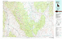 1981 Salmon1982 Print · USGSThe high mountain border between Idaho and Montana comes alive in the early 1980s as a landscape of remote mines and river junctions. Researchers can trace the heritage of the Beaverhead Mountains through sites like Elkhorn Mine, Silver King Mine, and the settlement of Wisdom.
 - 1988 Map of Elkhorn Hot Springs, 1989 Print
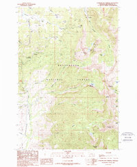 1988 Elkhorn Hot Springs1989 Print · USGSBeaverhead County mining and mountain life are captured here in the late eighties, centered on the thermal waters of Elkhorn Hot Springs. Trace the Old Railroad Grade to Coolidge or locate high-altitude operations like the Magna Mine and Park Mine.
End of results
Showing maps 1-2 of 2
Top cities near Elkhorn Hot Springs
Frequently asked questions
- What are the different types of historical maps available for Elkhorn Hot Springs?
- What is the oldest map of Elkhorn Hot Springs?
- Where can I purchase historical maps of Elkhorn Hot Springs for my home or office?
- Where can I download high-res historical maps of Elkhorn Hot Springs?
- Are there historical topographic maps available for Elkhorn Hot Springs?
- Is there historical aerial imagery available for Elkhorn Hot Springs?
- Where are historical maps of Elkhorn Hot Springs sourced from?