1990s Maps of Kidd, Montana
Explore 2 historic maps of Kidd from the 1990s. These maps offer a rare glimpse into what life looked like during the 1990s — showing old roads, neighborhoods, homes, and landmarks that have changed or disappeared over time.
Whether you're researching your family's past, planning a metal detecting trip, or studying how Kidd's landscape evolved across the 1990s, these high-resolution maps are a powerful tool for exploring the history of this region.
- Focus on a specific era: All maps on this page are from the 1990s, giving you a focused view of this time period.
- See what’s changed: Compare century-old streets, trails, and buildings to today's modern landscape using overlays and satellite layers.
- Research with precision: Use these maps for genealogy, historical research, land use analysis, or educational projects.
- View, download, or print: Maps are fully viewable online in high resolution, and can be downloaded or printed for your own records.
Start exploring Kidd's history through authentic maps from the 1990s. This is your window into the past.
Kidd, MT maps
(2)- 1992 Map of Lima, 1993 Print
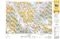 1992 Lima1993 Print · USGSThe high Divide country of Beaverhead County comes into focus in the early nineties, centered on the rail-and-ranching corridor through the Tendoy Mountains. Genealogists and historians can trace the Union Pacific line through Lima, Dell, and Monida, or locate the Silver Queen Mine and Kidd along the historic valley routes.
 - 1997 Map of Kidd, 2002 Print
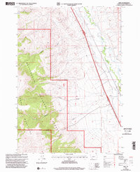 1997 Kidd2002 Print · USGSHigh Montana forest meets the river valley in the late nineties, showing the rugged interface of the Beaverhead National Forest. Trace family roots in Kidd or explore the drainage systems of Bell Canyon and Limekiln Creek.
End of results
Showing maps 1-2 of 2
Top cities near Kidd
Frequently asked questions
- What are the different types of historical maps available for Kidd?
- What is the oldest map of Kidd?
- Where can I purchase historical maps of Kidd for my home or office?
- Where can I download high-res historical maps of Kidd?
- Are there historical topographic maps available for Kidd?
- Is there historical aerial imagery available for Kidd?
- Where are historical maps of Kidd sourced from?