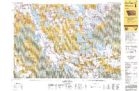
1992 Map of Lima
USGS Topo · Published 1993About this map
The Union Pacific railroad line and Highway 15 anchor this high-altitude landscape where the Continental Divide defines the boundary between Montana and Idaho. The small ranching communities of Lima and Dell sit in the heart of the valley, supported by the waters of the Red Rock River and the significant Lima Reservoir. This era of the early 1990s shows a region managed for diverse uses, from the operations at the Silver Queen Mine to the extensive protected lands within the Beaverhead National Forest and Red Rock Lakes National Wildlife Refuge. The terrain is dominated by the Tendoy Mountains and the Snowcrest Range, which overlook the broad Centennial Valley. Mapping by the Bureau of Land Management highlights the intricate mosaic of public and private land ownership that characterizes the American West during this period.
Find a feature on this map
69 named features on this map. Tap any name to fly to it.
Don’t see what you’re looking for? This feature index may not catch every label — zoom into the map to look around manually.
Map Details
Editions of this 1992 Lima Map
This is the sole edition of this map. No revisions or reprints were ever made.
Other maps of this area

1888 · Three Forks
USGS Topo · 1:250,000

1893 · Dillon
USGS Topo · 1:250,000

1894 · Three Forks
USGS Topo · 1:250,000

1895 · Three Forks
USGS Topo · 1:250,000

1947 · Bozeman
USGS Topo · 1:250,000

1948 · Bozeman
USGS Topo · 1:250,000

1949 · Varney
USGS Topo · 1:62,500

1950 · Lower Red Rock Lake
USGS Topo · 1:62,500

1950 · Monument Ridge
USGS Topo · 1:62,500

1952 · Eli Spring
USGS Topo · 1:24,000