1900s (20th Century) Maps of Rankin Place, Montana
Explore 7 historic maps of Rankin Place from the 1900s (20th Century). These maps offer a rare glimpse into what life looked like during the 1900s — showing old roads, neighborhoods, homes, and landmarks that have changed or disappeared over time.
Whether you're researching your family's past, planning a metal detecting trip, or studying how Rankin Place's landscape evolved across the 1900s, these high-resolution maps are a powerful tool for exploring the history of this region.
- Focus on a specific era: All maps on this page are from the 1900s, giving you a focused view of this time period.
- See what’s changed: Compare century-old streets, trails, and buildings to today's modern landscape using overlays and satellite layers.
- Research with precision: Use these maps for genealogy, historical research, land use analysis, or educational projects.
- View, download, or print: Maps are fully viewable online in high resolution, and can be downloaded or printed for your own records.
Start exploring Rankin Place's history through authentic maps from the 1900s. This is your window into the past.
Rankin Place, MT maps
(7)- 1932 Map of Red Lodge No 2
 1932 Red Lodge No 21932 Print · USGSCarbon County ranching country is documented in detail during the early 1930s, showing a landscape organized around mountain streams and rural post offices. Genealogists can locate family-named landmarks and country schools like Inderland Sch, Jackson Sch, and the community at Fishtail.
 - 1954 Map of Billings, 1963 Print
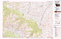
 1954 Billings1963 Print · USGSThe Yellowstone valley during the mid-fifties shows a landscape of thriving rail towns and high-mountain outposts. Genealogists and historians can trace old homesteads and mining routes near Red Lodge, Bearcreek, and along the Bighorn River.4 unique versions available
 - 1956 Map of Roscoe, 1957 Print
 1956 Roscoe1957 Print · USGSCarbon County ranching culture is frozen in time during the mid-fifties as family homesteads and irrigation systems networked the foothills. Genealogists can trace specific legacy holdings like the Youngstrom Ranch, Tony Cem, and the cluster of Boggio family properties.3 unique versions available
 - 1957 Map of Billings
 1957 Billings1957 Print · USGSThe Yellowstone River valley and the rugged Beartooth Mountains meet in the mid-1950s near the growing hub of Billings. Genealogists and researchers can trace rail and ranching history through river towns like Columbus, the mining heritage of Red Lodge, and the vast Crow Indian Reservation.
 - 1958 Map of Billings
 1958 Billings1958 Print · USGSMid-century Montana comes alive in this survey of the Yellowstone Valley as the regional rail and road networks reached their peak. Trace family roots and old routes near Billings, the Crow Indian Reservation, and the heights of the Beartooth Mountains.2 unique versions available
 - 1989 Map of Red Lodge
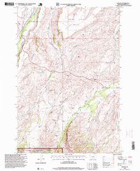
 1989 Red Lodge1989 Print · USGSThe Beartooth Mountains and the Montana-Wyoming border come alive in this late 1980s map of the high plateau country. Genealogists and historians can trace the mining history of Bearcreek through the Brophy Mine and Foster Mine or locate the rural Church Hill.
 - 1996 Map of Roscoe, 1999 Print
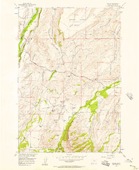
 1996 Roscoe1999 Print · USGSThe Carbon County ranchlands near the Beartooth foothills are documented here in the late twentieth century. Family historians can trace local lineages through homesteads like the Joe Boggio Ranch, Rankin Place, and the Tony Cem burial ground.
End of results
Showing maps 1-7 of 7
Frequently asked questions
- What are the different types of historical maps available for Rankin Place?
- What is the oldest map of Rankin Place?
- Where can I purchase historical maps of Rankin Place for my home or office?
- Where can I download high-res historical maps of Rankin Place?
- Are there historical topographic maps available for Rankin Place?
- Is there historical aerial imagery available for Rankin Place?
- Where are historical maps of Rankin Place sourced from?