1900s (20th Century) Maps of Red Lodge, Montana
Explore 10 historic maps of Red Lodge from the 1900s (20th Century). These maps offer a rare glimpse into what life looked like during the 1900s — showing old roads, neighborhoods, homes, and landmarks that have changed or disappeared over time.
Whether you're researching your family's past, planning a metal detecting trip, or studying how Red Lodge's landscape evolved across the 1900s, these high-resolution maps are a powerful tool for exploring the history of this region.
- Focus on a specific era: All maps on this page are from the 1900s, giving you a focused view of this time period.
- See what’s changed: Compare century-old streets, trails, and buildings to today's modern landscape using overlays and satellite layers.
- Research with precision: Use these maps for genealogy, historical research, land use analysis, or educational projects.
- View, download, or print: Maps are fully viewable online in high resolution, and can be downloaded or printed for your own records.
Start exploring Red Lodge's history through authentic maps from the 1900s. This is your window into the past.
Red Lodge, MT maps
(10)- 1944 Map of Red Lodge, 1946 Print
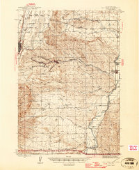 1944 Red Lodge1946 Print · USGSCarbon County’s coal and ranching economy is captured here in the mid-1940s, from the railhead at Red Lodge to the banks of the Clarks Fork Yellowstone River. Genealogists and industrial historians can trace the operations of the Smith Mine, the Ohio Oil Co Camp, and the rural Clear Creek Sch.3 unique versions available
 - 1954 Map of Billings, 1963 Print
 1954 Billings1963 Print · USGSThe Yellowstone valley during the mid-fifties shows a landscape of thriving rail towns and high-mountain outposts. Genealogists and historians can trace old homesteads and mining routes near Red Lodge, Bearcreek, and along the Bighorn River.4 unique versions available
 - 1956 Map of Mount Maurice, 1958 Print
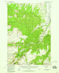 1956 Mount Maurice1958 Print · USGSRed Lodge sits at the edge of the Beartooth Front in the mid-1950s, a hub for high-country research and recreation. Genealogists and historians can trace local landmarks like Draper Sch, the Red Lodge Cemetery, and Camp Senia along the mountain foothills.4 unique versions available
 - 1957 Map of Billings
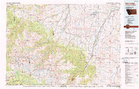
 1957 Billings1957 Print · USGSThe Yellowstone River valley and the rugged Beartooth Mountains meet in the mid-1950s near the growing hub of Billings. Genealogists and researchers can trace rail and ranching history through river towns like Columbus, the mining heritage of Red Lodge, and the vast Crow Indian Reservation.
 - 1958 Map of Billings
 1958 Billings1958 Print · USGSMid-century Montana comes alive in this survey of the Yellowstone Valley as the regional rail and road networks reached their peak. Trace family roots and old routes near Billings, the Crow Indian Reservation, and the heights of the Beartooth Mountains.2 unique versions available
 - 1969 Map of Red Lodge East, 1973 Print
 1969 Red Lodge East1973 Print · USGSRed Lodge and the surrounding coal-mining corridor are shown here in the late 1960s as industrial operations transitioned toward a new era. Genealogists can locate family sites near Bearcreek and Washoe, or trace the many mining operations like the Brophy Mine and Smith Mine.3 unique versions available
 - 1986 Map of Red Lodge West
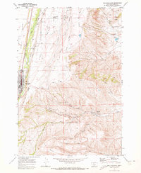
 1986 Red Lodge West1986 Print · USGSThe foothills of Carbon County meet the high peaks during the mid-eighties as the town of Red Lodge transitions into the wilderness. Trace local landmarks like the Cemetery, Rodeo Ground, and the dramatic Limestone Palisades above the creek forks.
 - 1989 Map of Red Lodge
 1989 Red Lodge1989 Print · USGSThe Beartooth Mountains and the Montana-Wyoming border come alive in this late 1980s map of the high plateau country. Genealogists and historians can trace the mining history of Bearcreek through the Brophy Mine and Foster Mine or locate the rural Church Hill.
 - 1996 Map of Red Lodge West, 1999 Print
 1996 Red Lodge West1999 Print · USGSThe Beartooth foothills come alive in the mid-nineties as the town of Red Lodge transitions into the high country of Custer National Forest. Researchers can trace the local development of the Red Lodge Mountain Ski Area, the historic Draper School, and the path of the Meeteetse Road.
 - 1996 Map of Red Lodge East, 1999 Print
 1996 Red Lodge East1999 Print · USGSCarbon County's coal mining and ranching roots are well-preserved here in the mid-1990s as the high benches drop into the coulees east of Red Lodge. Genealogists and historians can trace the legacy of industrial sites like Smith Mine and local landmarks such as Clear Creek School.
End of results
Showing maps 1-10 of 10
Top cities near Red Lodge
Frequently asked questions
- What are the different types of historical maps available for Red Lodge?
- What is the oldest map of Red Lodge?
- Where can I purchase historical maps of Red Lodge for my home or office?
- Where can I download high-res historical maps of Red Lodge?
- Are there historical topographic maps available for Red Lodge?
- Is there historical aerial imagery available for Red Lodge?
- Where are historical maps of Red Lodge sourced from?