1900s (20th Century) Maps of Ekalaka, Montana
Explore 7 historic maps of Ekalaka from the 1900s (20th Century). These maps offer a rare glimpse into what life looked like during the 1900s — showing old roads, neighborhoods, homes, and landmarks that have changed or disappeared over time.
Whether you're researching your family's past, planning a metal detecting trip, or studying how Ekalaka's landscape evolved across the 1900s, these high-resolution maps are a powerful tool for exploring the history of this region.
- Focus on a specific era: All maps on this page are from the 1900s, giving you a focused view of this time period.
- See what’s changed: Compare century-old streets, trails, and buildings to today's modern landscape using overlays and satellite layers.
- Research with precision: Use these maps for genealogy, historical research, land use analysis, or educational projects.
- View, download, or print: Maps are fully viewable online in high resolution, and can be downloaded or printed for your own records.
Start exploring Ekalaka's history through authentic maps from the 1900s. This is your window into the past.
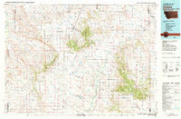
Ekalaka, MT maps
(7)- 1954 Map of Ekalaka, 1966 Print
 1954 Ekalaka1966 Print · USGSSoutheastern Montana and its borderlands with the Dakotas and Wyoming appear here in the mid-fifties, showing a remote ranching landscape. Genealogists can trace family roots through numerous rural landmarks like the Sherwin School, St Marys Ch, and Powderville.3 unique versions available
 - 1956 Map of Ekalaka
 1956 Ekalaka1956 Print · USGSSoutheast Montana and the Wyoming borderlands are shown here in the mid-fifties, capturing a landscape of remote ranching outposts and isolated country schools. Genealogists can trace family roots through landmarks like Boyes, Alzada, and Peabody School.
 - 1958 Map of Ekalaka
 1958 Ekalaka1958 Print · USGSSoutheast Montana in the mid-fifties remains a landscape of isolated ranching outposts and scattered schoolhouses. Genealogists and researchers can trace rural life through landmarks like Belltower, the McClary Ranger Station, and numerous family-named schools such as Davidson School.
 - 1965 Map of Ekalaka
 1965 Ekalaka1965 Print · USGSThe High Plains of Montana and Wyoming appear here in the mid-1950s, as a sprawling landscape of remote ranchlands and rural school districts. Researchers can trace the locations of many small landmarks like Mitchell School, Broadus, and the Humbolt Hills.
 - 1979 Map of Ekalaka
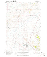 1979 Ekalaka1979 Print · USGSEkalaka and the surrounding Carter County high plains are captured here in the late seventies. Researchers can trace local landmarks like Wilder Butte, the town Cem, and the transition from prairie creeks to the Ekalaka Hills.
 - 1982 Map of Ekalaka, 1983 Print
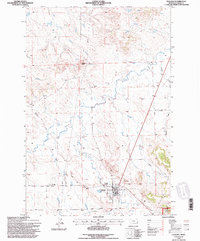
 1982 Ekalaka1983 Print · USGSEastern Montana ranching country and the tri-state border lands are meticulously documented in the early 1980s. Local historians can trace the remote settlement of Ekalaka, the landmarks of Medicine Rocks, and the rugged profiles of Chalk Buttes and Long Pine Hills.
 - 1993 Map of Ekalaka, 1996 Print
 1993 Ekalaka1996 Print · USGSThe ranchlands of Carter County are documented here in the early nineties, centered on the community of Ekalaka. Researchers can trace old travel routes like the Miles City Cutoff Road and locate landmarks from Wilder Butte to the local Cemetery.
End of results
Showing maps 1-7 of 7
Frequently asked questions
- What are the different types of historical maps available for Ekalaka?
- What is the oldest map of Ekalaka?
- Where can I purchase historical maps of Ekalaka for my home or office?
- Where can I download high-res historical maps of Ekalaka?
- Are there historical topographic maps available for Ekalaka?
- Is there historical aerial imagery available for Ekalaka?
- Where are historical maps of Ekalaka sourced from?