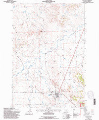
1993 Map of Ekalaka
USGS Topo · Published 1996About this map
Ekalaka serves as the central hub of this high-plains landscape, where the town grid is marked by municipal infrastructure including a Water Tank, Radio Tower, and Sewage Disposal facility. To the south, the Chalk Buttes rise above the surrounding terrain, marking the northern reaches of the Custer National Forest. The map documents a landscape defined by significant drainage systems, including the headwaters of the East Fork O'Fallon Creek and the meandering path of Little Beaver Creek.
Find a feature on this map
23 named features on this map. Tap any name to fly to it.
Don’t see what you’re looking for? This feature index may not catch every label — zoom into the map to look around manually.
Map Details
Editions of this 1993 Ekalaka Map
This is the sole edition of this map. No revisions or reprints were ever made.
Other maps of this area

1953 · Miles City
USGS Topo · 1:250,000

1954 · Ekalaka
USGS Topo · 1:250,000

1956 · Ekalaka
USGS Topo · 1:250,000

1957 · Miles City
USGS Topo · 1:250,000

1958 · Miles City
USGS Topo · 1:250,000

1958 · Ekalaka
USGS Topo · 1:250,000

1965 · Ekalaka
USGS Topo · 1:250,000

1979 · Beaver Flats South
USGS Topo · 1:24,000

1979 · Ekalaka
USGS Topo · 1:24,000

1979 · Beaver Flats North
USGS Topo · 1:24,000