1960s Maps of Great Falls, Montana
Explore 5 historic maps of Great Falls from the 1960s. These maps offer a rare glimpse into what life looked like during the 1960s — showing old roads, neighborhoods, homes, and landmarks that have changed or disappeared over time.
Whether you're researching your family's past, planning a metal detecting trip, or studying how Great Falls's landscape evolved across the 1960s, these high-resolution maps are a powerful tool for exploring the history of this region.
- Focus on a specific era: All maps on this page are from the 1960s, giving you a focused view of this time period.
- See what’s changed: Compare century-old streets, trails, and buildings to today's modern landscape using overlays and satellite layers.
- Research with precision: Use these maps for genealogy, historical research, land use analysis, or educational projects.
- View, download, or print: Maps are fully viewable online in high resolution, and can be downloaded or printed for your own records.
Start exploring Great Falls's history through authentic maps from the 1960s. This is your window into the past.
Great Falls, MT maps
(5)- 1965 Map of Antelope Butte, 1967 Print
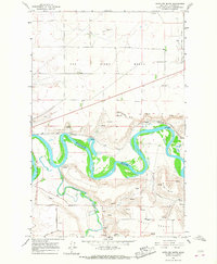 1965 Antelope Butte1967 Print · USGSCascade County's dramatic river-cut landscape is documented here in the mid-1960s as the Missouri and Smith Rivers wind through the plains. Trace the path of the Great Northern railroad or locate family landmarks like Antelope Butte and Wilson Butte.3 unique versions available
 - 1965 Map of Southeast Great Falls, 1968 Print
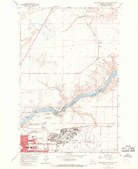
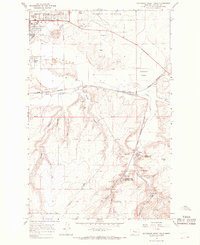 1965 Southeast Great Falls1968 Print · USGSThe mining settlements south of Great Falls come alive in the mid-1960s, showing a landscape defined by coal and the Great Northern rail lines. Genealogists can trace family roots through Sand Coulee, Centerville, and the Spring Mines.3 unique versions available
 - 1965 Map of Northwest Great Falls, 1968 Print
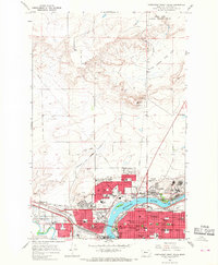 1965 Northwest Great Falls1968 Print · USGSMid-century Great Falls is a hub of industry and transport at the confluence of the Missouri and Sun rivers. Trace the rail lines of the Great Northern and local landmarks like the Black Eagle Dam or the Ursuline Academy.3 unique versions available
 - 1965 Map of Southwest Great Falls, 1968 Print
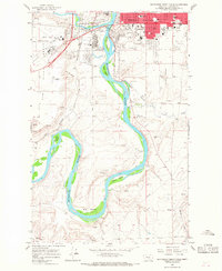 1965 Southwest Great Falls1968 Print · USGSGreat Falls expanded south toward the Big Bend of the Missouri River during the mid-sixties as the airport and interstate network matured. Genealogists can locate family sites in Mount Olivet Cemetery or trace landmarks like the College of Great Falls and Fisher Island.3 unique versions available
 - 1965 Map of Northeast Great Falls, 1968 Print
 1965 Northeast Great Falls1968 Print · USGSNortheast of Great Falls in the mid-sixties, the landscape reveals a heavy reliance on the river and the air base. Trace the industrial footprint of Ryan Dam and Malmstrom Air Force Base, or locate local landmarks like Giant Springs and Morningside Sch.3 unique versions available
End of results
Showing maps 1-5 of 5
Top cities near Great Falls
Top neighborhoods of Great Falls
- Eastside historical maps
- Southeast historical maps
- Westside historical maps
- Southside historical maps
- Northside historical maps
- Southwest historical maps
See more
Frequently asked questions
- What are the different types of historical maps available for Great Falls?
- What is the oldest map of Great Falls?
- Where can I purchase historical maps of Great Falls for my home or office?
- Where can I download high-res historical maps of Great Falls?
- Are there historical topographic maps available for Great Falls?
- Is there historical aerial imagery available for Great Falls?
- Where are historical maps of Great Falls sourced from?