1980s Maps of Highwood, Montana
Explore 2 historic maps of Highwood from the 1980s. These maps offer a rare glimpse into what life looked like during the 1980s — showing old roads, neighborhoods, homes, and landmarks that have changed or disappeared over time.
Whether you're researching your family's past, planning a metal detecting trip, or studying how Highwood's landscape evolved across the 1980s, these high-resolution maps are a powerful tool for exploring the history of this region.
- Focus on a specific era: All maps on this page are from the 1980s, giving you a focused view of this time period.
- See what’s changed: Compare century-old streets, trails, and buildings to today's modern landscape using overlays and satellite layers.
- Research with precision: Use these maps for genealogy, historical research, land use analysis, or educational projects.
- View, download, or print: Maps are fully viewable online in high resolution, and can be downloaded or printed for your own records.
Start exploring Highwood's history through authentic maps from the 1980s. This is your window into the past.
Highwood, MT maps
(2)- 1982 Map of Highwood, 1983 Print
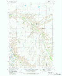 1982 Highwood1983 Print · USGSHighwood and the surrounding grain country are captured here in the early eighties, showing a landscape shaped by agricultural logistics and deep coulees. Trace the Old Railroad Grade past Highwood or locate the rural Cem near North Willow Creek.
 - 1984 Map of Fort Benton
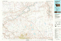 1984 Fort Benton1984 Print · USGSMid-century Montana life revolves around the river forks and rail lines in the years following the designation of the Wild and Scenic River. You can trace the Burlington Northern lines through Fort Benton, locate the Loma Ferry, and identify high points like Highwood Baldy or Square Butte.
End of results
Showing maps 1-2 of 2
Top cities near Highwood
Frequently asked questions
- What are the different types of historical maps available for Highwood?
- What is the oldest map of Highwood?
- Where can I purchase historical maps of Highwood for my home or office?
- Where can I download high-res historical maps of Highwood?
- Are there historical topographic maps available for Highwood?
- Is there historical aerial imagery available for Highwood?
- Where are historical maps of Highwood sourced from?